New swell for Sunday but with stubborn winds
Western Australia Surf Forecast by Craig Brokensha (issued Friday 21st December)
Best Days: Protected spots across the South West Sunday morning and Monday morning, South West magnets Tuesday morning
Recap
Wednesday's kick in swell held into yesterday morning but conditions were a bit bumpy across the exposed South West breaks with a S/SE-SE breeze, workable but not ideal. Further north was cleaner but only tiny, and best in Mandurah to 1-1.5ft.
Today the swell has eased further with a straight gusty offshore wind across the South West, best on the magnets with fading sets from 3ft, tiny to the north.
Today’s Forecaster Notes are brought to you by Rip Curl
This weekend and next week (Dec 22 – 28)
The surf will continue to bottom out tomorrow, and seeing the lack of size across the South West this morning, there probably won't be anything really surfable left across the state.
Conditions should be great with an offshore E/NE wind, tending N/NW ahead of sea breezes.
We then look towards our inconsistent but fun sized mid-period SW swell due Sunday/Monday, with it being generated through this week by a distant and slow moving low west of the Heard Island region.
The swell might not be at size at dawn Sunday but should build quickly to 4-5ft in the South West, 1-1.5ft in Mandurah and tiny in Perth, with a peak due on Monday morning to 4-6ft and 1-2ft respectively (still tiny in Perth).
Winds on Sunday are still less than ideal and out of the S/SE across the South West, better and variable to the north though still tiny in the morning. Afternoon sea breezes will create bumpy conditions, while as the swell peaks Monday morning, similar S/SE winds are due across all locations.
Tuesday still looks cleaner with an SE tending E/SE offshore ahead of sea breeze, but smaller easing surf from the 4ft+ range in the South West, tiny to the north.
 Wednesday looks like a lay day as is Thursday with the swell dropping further and bottoming out with morning S/SE winds on the former and SW winds on the later.
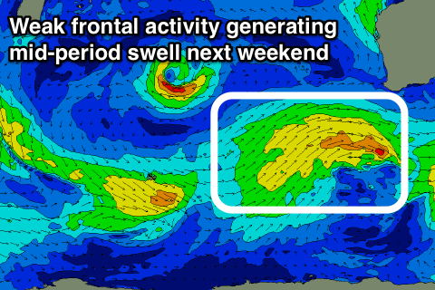
This onshore breeze which will linger into the end of the week and next weekend will be linked to weak polar fronts pushing up and close to us through the middle to end of next week, providing no decent size and also spoiling conditions.
Building surf is expected later Friday and more so into the weekend, peaking Sunday to 4-5ft+ or so across the South West, easing slowly Monday the 31st with improving winds, but we'll have a closer look at this on Monday. Have a great weekend!

