Pumping surf through the week worth making the most of
Western Australia Surf Forecast by Craig Brokensha (issued Monday 1st October)
Best Days: Tuesday morning, Wednesday, Thursday (morning Perth and Mandurah), Margs Sunday morning
Recap
Great waves across the South West Saturday, a little hit and miss yesterday with winds tending more S/SE. Mandurah and Perth were best Saturday as well, tiny though still clean Sunday.
Today a new swell is filling in and conditions were a little lumpy with S/SE winds across the South West early, more offshore now, bumpy and 1-2ft in Mandurah and 1-1.5ft in Perth.
The groundswell on the build today should reach 5-6ft across the South West this afternoon, 2ft in Mandurah and 1-2ft in Perth as winds hold from the SE.
Today’s Forecaster Notes are brought to you by Rip Curl
This week and weekend (Oct 2 - 7)
Today's building SW groundswell should peak overnight and ease back through tomorrow with favourable E/SE-SE offshore winds, stronger SE into the afternoon.
Margs should ease back from 4-6ft across swell magnets, 2ft on the sets across Mandurah and 1-2ft Perth, smaller into Wednesday morning.
The low point in swell will only be temporary though with a large long-period S/SW groundswell due to fill in rapidly through the morning ahead of a peak into the afternoon.
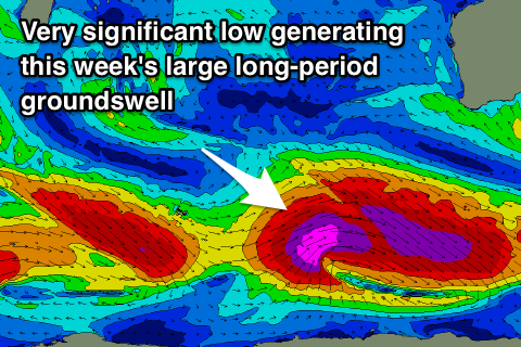
 This groundswell has been upgraded since last week, with the severe low we've been discussing the last couple of updates now due generate its strongest winds in our swell window before pushing east under the country.
We'll see a broad pre-frontal fetch of severe-gale W/NW winds produce an active sea state for post-frontal severe-gale to storm-force W/SW winds to move over, producing a large pulse of long-period SW groundswell Wednesday kicking to 8-10ft on the exposed reefs across the South West, 3ft in Mandurah and 2ft+ in Perth.
Winds look great with all day offshore E/SE winds, similar Wednesday as the swell eases back from 6ft+, 2ft+ and 1-2ft respectively. Perth and Mandurah will actually see winds swing NE to NW as a small low forms off the coast and drifts slowly south.
This looks to bring average winds to all locations Friday, onshore out of the SW in Perth and S tending S/SW across the South West as the swell continues to ease.
We should see winds slowly improve over the weekend with smaller pulses of background SW groundswell, generated by polar fetches of strong to gale-force W/NW winds.
The best pulse is due Friday afternoon and Saturday morning, coming in at 4-5ft+ across the South West, 1-2ft Mandurah and tiny in Perth. S/SE winds will create less than ideal but workable conditions, E'ly Sunday with smaller surf.
Longer term there's nothing significant on the cards, so make the most of the coming week of waves and check back here Wednesday for the latest.

