Fun swells over the coming period with generally favourable winds
Western Australia Surf Forecast by Craig Brokensha (issued Friday 28th September)
Best Days: Swell magnets tomorrow, Sunday morning, protected spots Monday, every morning next week (Perth Tuesday and Thursday mornings)
Recap
A slow start to Perth and Mandurah yesterday morning with favourable winds, bigger with a new long-period W/SW groundswell into the afternoon with winds remaining good for protected spots around Mandurah.
Margs saw good clean conditions with solid surf in the 6ft range through the morning, bumpy and larger into the afternoon.
This morning the swell has cleaned right up across all locations with pumping 6ft+ waves across the South West, 2-3ft in Mandurah and 2ft+ in Perth.
Today’s Forecaster Notes are brought to you by Rip Curl
This weekend and next week (Sep 29 – Oct 5)
The large long-period W/SW groundswell seen at the end of this week will continue to ease tomorrow but with great winds for swell magnets. Margs should still see sets in the 3-5ft range tomorrow morning, smaller and back to 2ft on the sets around Mandurah, 1-1.5ft+ in Perth.
Conditions will be great with a fresh to strong and persistent E/NE offshore, tending variable into the afternoon.
 Sunday will remain clean through the morning with a SE-E/SE offshore across Margs, E/NE further north, but an inland trough come low moving offshore looks to bring stronger S'ly winds to the south and S/SW winds in Perth and Mandurah into the afternoon.
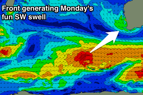
Our new SW groundswell is still on track along with the stronger pulse for Monday afternoon, generated by pre and post-frontal fetches of W/NW-W/SW gales.
The best aligned fetch of W/SW gales will generate the biggest increase in size on Monday, but coming back to Sunday and we should see wave heights hanging in at 3-5ft across the South West, 1-1.5ft further north in Perth and Mandurah.
Monday's pulse looks to come more around 5-6ft across Margs, 2ft in Mandurah and 1-2ft Perth into the afternoon but winds will remain less than ideal and out of the S/SE in the wake of Sunday's change. The morning looks a good chance for a better SE'ly across all regions.
Winds will swing back offshore to the E/SE each morning for the rest of the week as a strong high moves in to position to our south-west but this will also block most of the strong frontal systems that are developing to our south.
One such system will be quite large in scope, with a significant fetch of pre-frontal severe-gale W/NW winds producing a moderate to large SW groundswell and active sea state for post-frontal severe-gale W/SW-SW winds to move over.
Two strong pulses of long-period SW groundswell will be generated, arriving around the same time and that being late Wednesday, with a peak Thursday morning.
The South West should see 6ft+ sets at the peak of the swell, 2ft to occasionally 3ft waves in Mandurah and 2ft in Perth with that morning E/SE offshore.
Longer term our run of good winds will continue with a couple of good long-period groundswells also on the cards. More on this Monday, have a great weekend!

