Smaller swells but better winds
Western Australia Surf Forecast by Craig Brokensha (issued Wednesday 19th September)
Best Days: Keen surfers early tomorrow and Friday across the South West, swell magnets across the South West Saturday and Sunday and Monday morning, next Wednesday onwards
Recap
Great waves across Mandurah and Perth yesterday morning with Monday afternoon's large increase in swell easing from a clean 3-4ft and 3ft respectively.
Margs remained large but average with onshore S-S/SW winds.
This morning the swell was smaller and back to 2-3ft in Mandurah, 2ft in Perth with good clean conditions again. Margs was also cleaner but still bumpy though improving with the swell back to the 4-6ft range and best in protected spots.
Today’s Forecaster Notes are brought to you by Rip Curl
This week and weekend (Sep 20 - 23)
Winds will finally swing offshore across the Margaret River region tomorrow morning, just as the swell bottoms out.
A light early E/NE breeze is expected, swinging more N/NE through the morning and fresh NW into the afternoon with an approaching trough.
Size wise we're looking 4ft leftovers, with maybe 1-2ft sets across Mandurah, tiny in Perth, while a new SW groundswell should build into the afternoon and peak Friday morning.
This swell won't offer too much size, with it generated by unfavourably aligned pre-frontal W/NW gales.
 Swell magnets in the South West should hopefully see 3-5ft sets Friday morning, tiny to the north along with variable winds (hopefully tending E/NE through the morning) and then W/NW into the afternoon but without much strength.
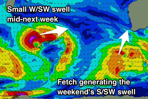
The weekend is looking a bit better as a deepening inland surface trough come mid-latitude low directs persistent and gusty offshore E/SE-SE winds across us along with a fun new mid-period S/SW swell.
This swell will be generated by a broad but relatively weak polar frontal system projecting towards us through the end of the week, with the swell due to arrive through Saturday and build into the afternoon, reaching 4-5ft as afternoon winds tend SE. With the south direction and weak nature of the swell Perth and Mandurah look to remain tiny.
Sunday will be super fun with the swell easing from a similar if not slightly smaller size with the E/SE offshore.
Longer term a new small W/SW groundswell is on the cards the the middle of next week, followed by a very inconsistent long-period, long-range W/SW groundswell late in the week.
The long-period swell will be generated by a broad and slow moving storm forming south of South Africa later this week, in our far swell window before tracking slowly east through the weekend and then weakening.
At this stage we're looking at infrequent sets to 6-8ft across the South West with offshore winds, but more on this Friday.

