Poor across Margs, a couple of pumping windows to the north
Western Australia Surf Forecast by Craig Brokensha (issued Wednesday 5th September)
Best Days: Perth and Mandurah tomorrow, early Sunday Perth and Mandurah
Recap
Poor small to tiny onshore swells yesterday, building into the afternoon and larger today with a mix of windswell and building groundswell but with a continuation of poor conditions though workable winds for protected spots.
The groundswell component is due to peak this afternoon to 12ft+ across the South West, 4-5ft in Mandurah and 3-4ft in Perth as winds remain poor.
Today’s Forecaster Notes are brought to you by Rip Curl
This week and weekend (Sep 6 - 9)
This afternoon's mix of building W/SW groundswell and localised windswell are due to start easing through tomorrow and with our window of favourable conditions across Perth and Mandurah.
A morning E/NE offshore is expected while Margs will remain onshore with a moderate to fresh W/NW breeze. We should see easing sets from 3-4ft across Mandurah, 3ft in Perth with winds remaining favourable until early-mid afternoon, creating a great day of surfing.
Onshore winds will kick back in across all locations on Friday from the W tending W/SW as a polar front pushes up and across the coast. This will kick up some new mid-period SW swell later in the day but more so Saturday, with the front developing in the Heard Island region today.
Wind speeds won't be too impressive, but the South West should kick to 6ft+ through Saturday with 2-3ft waves in Mandurah and 2ft+ waves in Perth but with persistent W/NW winds.
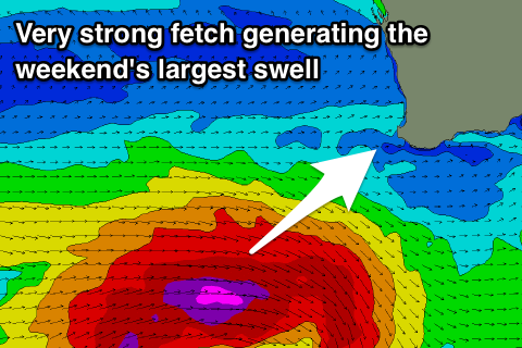
 Of greater importance is a much stronger storm forming west-southwest of us on Friday generating a fetch of severe-gale to storm-force W'ly winds through our south-western swell window.
An oversized long-period SW groundswell should result, filling in Sunday and peaking through the middle of the day to 10-12ft or so, 3-4ft in Perth and 3ft in Mandurah.
Winds will swing more NW and freshen creating terrible conditions across the South West, while Perth and Mandurah should see early NE breezes.
Unfortunately as the swell eases on Monday onshore winds will kick back in across all locations from the west, with yet another front approaching from the west-southwest.
This front won't be as strong, but will be slow moving and produce another oversized W/SW swell for Tuesday. Winds look to possibly improve and swing more S/SW-SW with Wednesday possibly offshore as it eases, but more on this Friday.

