XXL surf next week with offshore winds north of a point
Western Australia Surf Forecast by Craig Brokensha (issued Friday 13th July)
Best Days: Dawn Perth and Mandurah Saturday, Perth and Mandurah Tuesday and Wednesday morning
Recap
Another great morning of surf across all locations yesterday with a new mid-period W/SW swell and offshore winds ahead of a fresher NW'ly into the afternoon.
Today we've got a large and powerful W/SW groundswell filling in across the state but with poor and fresh onshore winds.
Today’s Forecaster Notes are brought to you by Rip Curl
This weekend and next week (Jul 14 - 20)
Want to receive an email when these Forecaster Notes are updated? Then log in here and update your preferences.
This weekend is looking generally poor with onshore winds and easing surf from today, but our small window of cleaner conditions tomorrow around Perth and Mandurah is still more than likely.
In between fronts we're likely to see local land breezes producing N/NE winds at dawn, swinging back to the NW through the morning and then strengthening into the afternoon.
Solid easing sets from 3-4ft are due across Mandurah, with 3ft sets in Perth, while Margs looks to be around the 10ft range but a mess with gusty W/NW winds ahead of a late SW change.
Sunday will be average across all locations with a fresh to strong SW tending W/SW breeze in the wake of a front pushing up and into us Saturday evening.
There's an outside chance Perth may see a dawn S/SE breeze, and with this some leftover swell to 2ft to occasionally 3ft, but our attention turns to the more serious swell energy due early next week.
Currently a node of the Long Wave Trough is strengthening just west of us and will push across us through the weekend.
With this we'll see a vigorous polar front that's formed west of Heard Island projecting a great fetch of severe-gale W/NW winds east along the polar shelf before tracking back up towards us, swinging W/SW through tomorrow afternoon and evening.
 This will produce a large long-period SW groundswell (Monday) and active sea state for a much more significant fetch of storm-force W/SW winds to move on top of. We'll see this storm-force fetch developing on the tail of the initial frontal system and project ideally east-northeast towards the south-west corner of the state from tomorrow through Sunday before weakening on Monday while pushing further east through the Bight.
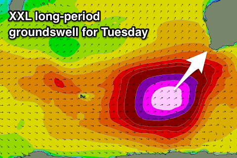
What will result is an XXL long-period SW groundswell with a lot of the size falling in that high 18s band.
Large levels of SW groundswell are due to build through Monday across all locations but with strong W/SW winds as the severe storm clips the state. Our high that's set to move in through Tuesday will arrive a touch slower forecast on Wednesday resulting in lingering moderate to fresh SW winds across the South West at dawn, easing and tending W'ly.
This will be as the XXL SW groundswell fills in, with a peak due through the middle of the day/early afternoon across the South West, more so afternoon Mandurah and Perth.
Size wise we're looking at an upgrade from Wednesday with the ideal track and captured fetch motion towards the WA coast. Margs looks to be huge and 20ft+ across exposed locations, much larger at deepwater offshore reefs.
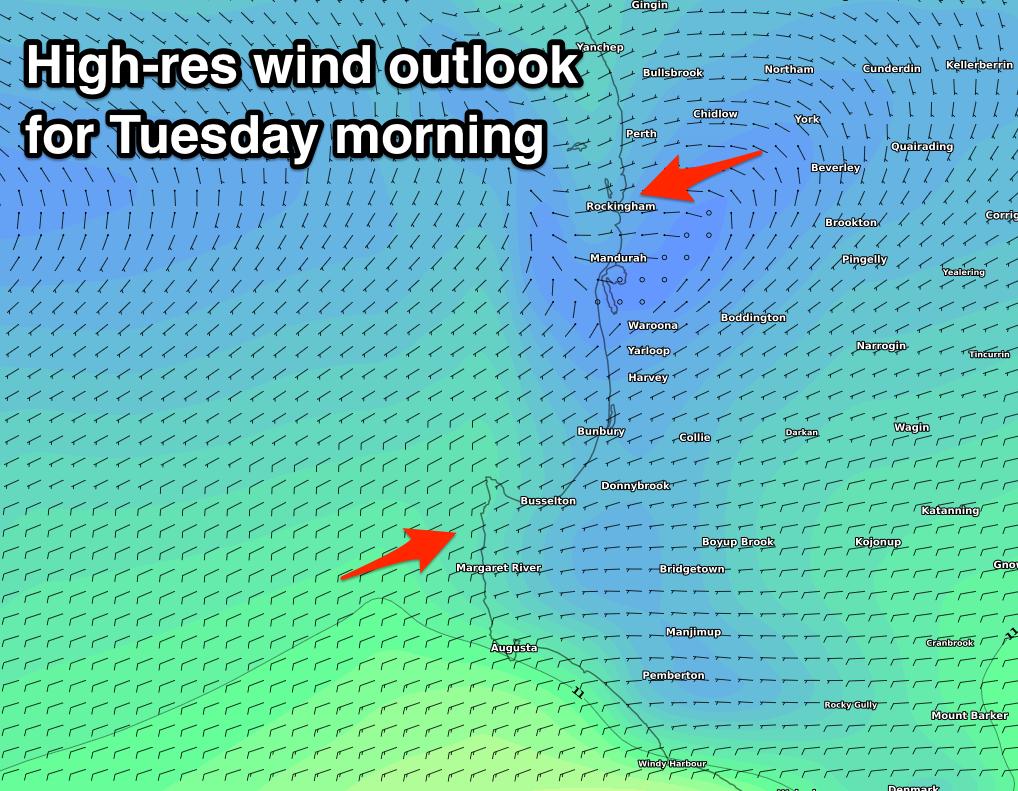
Mandurah will likely build to 6ft+, with 4-5ft surf at magnets in Perth. Perth and Mandurah will sit far enough north that local land breezes should create E'ly offshore breezes during the morning, tending light to moderate W'ly through the day.

Come Wednesday we'll see the swell still coming in at a very large 12-15ft or so across the Margs reefs, easing steadily through the day, with easing 3-5ft waves in Mandurah and 3ft+ surf in Perth.
Another strong low pushing in quickly from the west will see winds swing back to the N/NW though around the South West (possibly N/NE at dawn) with cleaner conditions around Perth and Mandurah under an E/NE-NE breeze.
Longer term the strong low looks to generate a new large W/SW groundswell for late week, while XL stormy surf is on the cards for next weekend as another strong node of the Long Wave Trough forms in the Indian Ocean.
More on this Monday though. Have a great weekend!

