Magnets tomorrow, slim window Thursday morning then large from Friday
Western Australia Surf Forecast by Craig Brokensha (issued Monday 9th July)
Best Days: Margs tomorrow, dawn Thursday all regions, Perth and Mandurah early Saturday
Recap
It's great to be back after my sojourn around the Basque Country, if you get a chance it's more than worth a trip.
Pumping waves over the weekend with favourable winds and good sized swells, kicking through yesterday with the arrival of a new groundswell. Margs faired best with options right across the cape.
Today the swell has eased right back, with favourable winds across most locations before winds tended more N'ly in regions across Margs this afternoon.
Today’s Forecaster Notes are brought to you by Rip Curl
This week and weekend (Jul 10 - 15)
Want to receive an email when these Forecaster Notes are updated? Then log in here and update your preferences.
We're looking at another day of clean conditions tomorrow with a small reinforcing swell that will continue to provide fun waves across the South West.
Surf in the 4ft range is expected with the odd bigger one at magnets under an E/NE breeze that will tend variable and possible light onshore later in the day. Perth and Mandurah look to hang around 1ft.
The swell will drop back into Wednesday as winds become less favourable with light onshore though possibly SW winds across the South West (light SE to the north) swinging more W/SW through the day.
A fun new W/SW swell should be seen into the afternoon, generated by a good mid-latitude front that's currently to our west, north of the Heard Island region.
 The swell will be mid-period though provide fun waves early Thursday when it peaks under a dawn NE breeze that will quickly freshen from the N/NE and tend N/NW with an approaching front.
Margs is looking to come in around 4-5ft with 2ft sets in Mandurah and Perth.
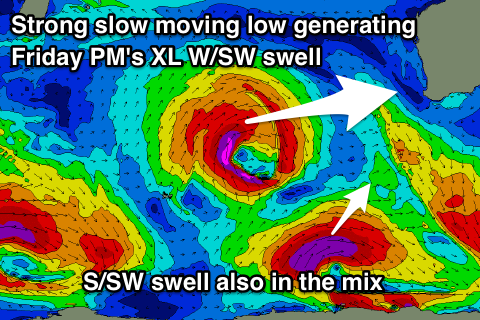
The strengthening N/NW wind associated with the approaching front will bring with it a new extra-large W/SW groundswell, with the earlier stages of the front being a vigorous storm that's currently formed south-east of South Africa.
We'll see a fetch of gale to severe-gale W/SW winds projected slowly and ideally through our western swell window, with a low pressure centre forming as the storm continues moving towards us.
An XL long-period W/SW groundswell will result, building rapidly through Friday mixed in with some weak W/SW windswell from the storm crossing the coast.
Onshore W'ly tending W/SW winds are expected as Margs builds to the 12ft+ range, 3-5ft in Mandurah and 3-4ft in Perth.
The swell will ease through Saturday but unfortunately another storm approaching from the South West will bring pre-frontal W/NW winds, creating poor conditions. Perth and Mandurah at this stage look to possibly see an early E/NE breeze, but we'll confirm this Wednesday and Friday.
The weekend's approaching storm will be the first in a flurry of strengthening and broadening activity in our south-western swell window as a strong node of the Long Wave Trough sets up from across our South West back across the southern Indian Ocean.
With this we're due to see back to back large to extra-large SW groundswells through early next week with possible favourable winds Tuesday/Wednesday as a high quickly slides in. More on this Wednesday.


Comments
Margs is a sight for sore eyes this morning.
