Good weekend for swell magnets, less than ideal next week
Western Australia Surf Forecast by Craig Brokensha (issued Friday 20th October)
Best Days: Swell magnets in the South West Saturda and Sunday morning, South West Tuesday morning
Recap
Great waves across most breaks yesterday with an improving 6ft+ of swell across the South West, and 2-3ft up around Mandurah and Perth.
The swell has eased into this morning back to the 5ft range across the South West and 2ft on the sets further north with a strong offshore wind creating tricky conditions across the cape.
Winds should hold until mid-late afternoon before giving into late sea breezes.
This weekend and next week (Oct 21 - 27)
This weekend will be all about the swell magnets in the South West. We'll see our current swell continuing to ease, dropping back from 3ft to occasionally 4ft at swell magnets in the South West, 1ft+ to the north (Mandurah/Perth), even smaller Sunday.
Conditions will be great though with a fresh E'ly tomorrow morning, easing into the afternoon ahead of late sea breezes and then fresh E/NE tending variable winds ahead of sea breezes.
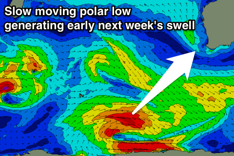
Some new SW groundswell should build through Monday and peak Tuesday, produced by a slow moving polar low forming south-west of us today, persisting through most of tomorrow before weakening tomorrow evening.
 The longevity of the low will see the swell hang around for a little longer, but there's no major size due across Mandurah or Perth, hardly topping 1-1.5ft into Monday afternoon and Tuesday.
Margs should build to 4ft later in the day Monday (smaller early) and hold Tuesday in the 4-5ft range, easing through Wednesday.
Winds are suss Monday as a trough drifts east resulting in S'ly winds across Margs, variable early to the north, while more variable breezes are due everywhere come Tuesday. This will be ahead of a mid-latitude front and W'ly onshore winds Wednesday.
This frontal system should generate some new moderate sized W/SW groundswell for later in the week, but a secondary strong frontal progression pushing in behind this initial activity will generate some larger mid-period swell on top, for Friday.
At this stage we're looking at poor onshore waves in the 8ft range across the South West and 2-3ft further north, but we'll look at this again Monday.
Beyond this a good long-period SW groundswell is also on the cards for early the following week with more favourable winds, but more on this Monday. Have a great weekend!

