Stormy onshore waves easing tomorrow, followed by groundswell, clean and easing Thursday
Western Australia Surf Forecast by Craig Brokensha (issued Monday 16th October)
Best Days: Thursday, Friday, Saturday and SUnday mornings in the South West
Recap
Small clean waves across magnets in the South West Saturday morning but only to 3ft or so, while Mandurah offered small 1-2ft sets, tiny around Perth.
A touch more size was seen Sunday but onshore winds moved in across the South West and Mandurah, cleaner for a period around Perth but still tiny.
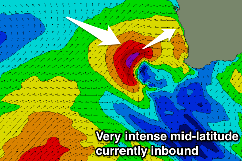
Today's we've got strengthening onshore winds and building levels of storm swell that'll get quite sizey later today. This is linked to an intense mid-latitude low moving in from the west, but more on this below.
This week and weekend (Oct 17 - 22)
We're currently seeing a very intense but weakening mid-latitude low moving in from the west, with satellite observations confirming that a fetch of severe-gale to storm-force SW winds have been generated in the northern half of the state's swell window.
 The low is now moving in from the west while generating a weakening fetch of gale to severe-gale W/SW winds and will pass across us this evening.
What we'll see is an oversized-XL swell generated for the northern half of the state, peaking tomorrow morning, grading smaller across Perth and Mandurah with Margs seeing more windswelly waves with less size.
Winds will remain poor and onshore from the W/NW (strong across the South West) with stormy easing waves from 4-5ft+ around Perth and Mandurah, 6ft+ across the South West.
A secondary broad but weakening polar front projecting up and into us today and tomorrow will generate a new SW groundswell for later Wednesday, followed by a secondary reinforcing S/SW groundswell Thursday morning.
We should see Margs building to 6-8ft later in the day, smaller early with an easing windswell while Perth and Mandurah should stay in the 3ft range all day. Poor conditions will continue across all locations with a fresh SW”ly in the South West and Mandurah, more S/SW around Perth.
Thursday will see the swell easing from a similar if not slightly smaller size and a ridge of high pressure edging in from the west should swing winds offshore out of the E across all locations, as mentioned last update.
This is the best day to surf with the size of the swell, while Friday will see fresh E/NE winds and smaller surf.
A deepening coastal trough will squeeze the high from the north, slowly pushing it away to the south-east resulting in smaller surf with winds tending more towards the north-east.
We may see some small SW groundswell energy early next week, but another high to our west-southwest looks to keep the activity at a minimum. Check back here Wednesday for the latest on this.

