Not the best weekend, onshore and stormy early next week
Western Australia Surf Forecast by Craig Brokensha (issued Friday 13th October)
Best Days: Saturday morning swell magnets across the South West, Thursday onwards
Recap
Good waves across all locations yesterday with a variable tending light offshore wind across the northern half of the Margaret River region and 5-6ft surf, 2-3ft up in Mandurah and 2ft around Perth.
Today was cleaner again but smaller with the swell dropping back to 4ft across the South West (pictured below), 2ft in Mandurah and 1-2ft in Perth.
This weekend and next week (Oct 14 - 20)
Tomorrow morning should mark a low point in swell activity ahead of some new SW groundswell later in the day, easing Sunday.
This swell isn't too significant and should provide 3-5ft waves across the South West late tomorrow and Sunday morning with 1-1.5ft waves to the north.
 Conditions will be good tomorrow with a light E/SE offshore developing before afternoon sea breezes kick in, creating poor conditions. Sunday is looking a little dicey with variable winds expected around Mandurah and Perth along with light S'ly winds in the South West.
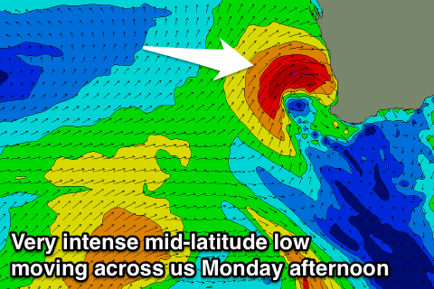
We'll see the swell continue to ease into Monday with deteriorating conditions as an intense mid-latitude low approaches from the west, bringing strengthening N/NW tending NW winds (gale-force Perth and Mandurah).
This mid-latitude is quite tricky as it'll see too far north of Margs initially when its at its strongest, aiming a tight fetch of severe-gale W'ly winds into the Jurien Bay and Geraldton regions before moving across us through the evening, bringing strong onshore W/SW tending winds to all locations Tuesday.
Perth should see a late increase in stormy NW swell with strong to gale-force W/NW winds, easing out of the W Tuesday with those onshore breezes. We're probably looking at stormy 3-4ft surf, with Mandurah coming in around a smaller 3ft, while Margs will miss all the NW energy, with some junky W'ly swell to 4-5ft or so Tuesday.
A secondary weak polar front projecting towards us early next week should generate some fun SW swell for Wednesday, while a secondary similar front should generate a reinforcing pulse for Thursday afternoon.
We're looking at surf to 4-6ft across the South West and 2ft to the north with onshore SW winds Wednesday, while Thursday's pulse looks a touch stronger and with morning offshore E/SE winds.
Easing surf with offshore winds is then expected into the end of the week and Saturday with nothing too major beyond that. Have a great weekend!

