Onshore winds and west swells
Western Australia Surf Forecast by Craig Brokensha (issued Monday 18th September)
Best Days: No great days with onshore winds for the coming period
Recap
Pumping surf on Saturday with a good swell and offshore winds across all locations, while yesterday was much smaller and onshore across the region.
Today a large SW groundswell filled in, offering great 8-10ft sets across the South West and 3ft sets further north along with light morning offshores. Winds have since deteriorated across all locations and we've got a poor run of conditions over the coming forecast period.
This week and weekend (Sep 19 – 24)
Today's large swell was generated by a very intense and slow moving low that formed south-west of us on the weekend. This low pushed slowly east, and continued to produce a fetch of severe-gale to storm-force SW winds in our southern swell window yesterday.
This has generated a large reinforcing S/SW groundswell for tomorrow across the South West but winds will remain poor and out of the W/NW across all locations (lighter early around Perth).
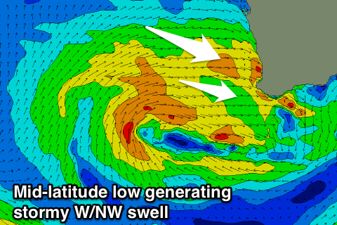
This onshore wind is linked to a mid-latitude low that's currently to our west-southwest, with this system, generating a slow moving fetch of strong to gale-force W/SW winds in our western swell window.
 The low is expected to continuing moving slowly east-southeast and more into our south-western swell window.
We'll see moderate to large pulses of W/SW tending SW swell, building through Wednesday and then easing through Thursday.
The South West should build to 6-8ft through Wednesday, with 2-3ft sets developing around Perth and Mandurah.
Due to the slow moving nature of the low though we'll see W'ly tending W/NW winds on Wednesday strong from the N/NW tending W/NW Thursday as another strong mid-latitude low moves in and across us.
This low will come in from quite a northerly position, bringing poor amounts of W/NW swell through Friday along with strong onshore winds.
All coasts will see sizey stormy waves developing, with a SW change due later Friday as the system continues on its way east.
Behind it a strong polar front is due to fire up, and form into another mid-latitude system, bringing further levels of W'ly swell but possibly offshore winds early next week as the system drifts east across us. More on this Wednesday as the models are divergent regarding the makeup of this system.

