Easing SW swell tomorrow, large long-period SW groundswell for Monday
Western Australia Surf Forecast by Craig Brokensha (issued Friday 15th September)
Best Days: Perth and Mandurah Saturday morning, all coasts Monday morning
Recap
Great waves across all locations again yesterday with surf in the 6ft range across the South West, 2-3ft in Mandurah and 2ft up in Perth.
This morning the swell was a touch smaller again with 4-5ft waves in the South West and 1-2ft surf to the north, but we should see a new SW groundswell building into this afternoon as winds tend variable.
This week and weekend (Sep 16 – 22)
These notes will be brief as Ben’s away today.
This afternoon's increase in SW groundswell should reach 6ft to occasionally 8ft on dark across the South West and 2ft to the north, easing back from the 6ft and 2ft+ range respectively tomorrow morning.
Our onshore W/NW breeze is still on the cards for the South West, with variable winds around Perth early before the onshore kicks in.
Sunday then looks average across all locations with a SW breeze, tending more W'ly through the day across the South West.
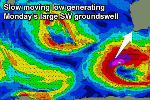
Some new W/SW swell should build into the afternoon, generated by a tight and intense mid-latitude low that's currently north-east of Heard Island.
 This low will deepen into a much more significant Southern Ocean storm this evening, with an initial fetch of severe-gale W/SW winds due to reach the storm-force range as the low stalls to our south-southwest tomorrow.
The system will slowly move east Sunday out of our swell window, but trailing fetches of severe-gale S/SW winds will continue to be aimed in our southern swell window.
What we'll see is a large powerful long-period SW groundswell produce for Monday morning, followed by a reinforcing S/SW groundswell Tuesday afternoon.
The South West should see large 8-10ft+ waves, easing through the day, back to a smaller 6ft Tuesday, holding into the afternoon.
Perth and Mandurah will see 2-3ft waves later Sunday from the W/SW swell, with Monday's swell coming in at a similar size.
Winds Monday morning will be great with E/NE offshore breezes developing across all locations, tending N/NW into the afternoon across the South West and variable to the north.
Tuesday then looks onshore across all spots with another approaching mid-latitude front.
Some new moderate sized W/SW swell is due off this low, but of greater significance is the activity behind it with a significant cold-outbreak due later next week across the state.
We'll see a mid-latitude storm direct a slow moving fetch of severe-gale W/SW winds towards us, generating a large but onshore W/SW groundswell later in the week. More on this Monday though. Have a great weekend!

