Slim windows of clean conditions
Western Australia Surf Forecast by Craig Brokensha (issued Monday 14th August)
Best Days: Perth and Mandurah Thursday morning, protected spots in the South West Friday out of the N/NE wind, early Saturday in the South West
Recap
Very poor conditions over the weekend with no lack of swell but also nowhere clean to surf.
This morning the swell was again a total mess with XL stormy surf in the South West, and large chunky waves around Mandurah and Perth to 4ft or so.
This week and weekend (Aug 15 - 20)
We've got to weather a few more days of stormy large surf before conditions start to improve late week.
The broad multi-centred low responsible for the large run of storm surf will start moving slowly east over the coming days but as it does so, a couple of trailing fronts will slam into the state.
The first system will push up and into us this evening, with a fetch of strong to gale-force SW winds generating a large SW swell tomorrow afternoon. This will be mixed in with large levels of W/SW swell, coming in around the 10ft+ range across the South West and 3ft+ in Perth (3-4ft Mandurah) with strong but easing W/SW winds.
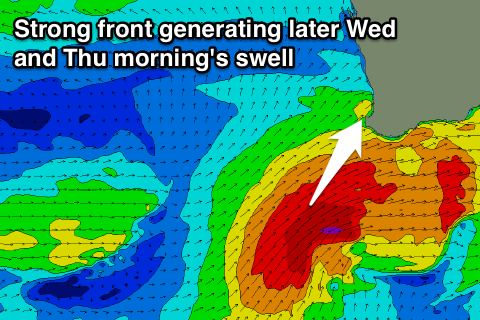
 The final vigorous frontal system in this progression will direct a fetch of severe-gale SW winds up into the south-west corner of the state over the coming days, pushing under us Wednesday afternoon.
A large SW groundswell is due off this front, building Wednesday afternoon to the 10ft+ range with a peak Thursday morning to 10-12ft in the South West and 3-4ft in Perth and Mandurah.
Winds will remain poor and onshore from the W/SW-SW Wednesday, strengthening from the W/NW Thursday with a developing and encroaching mid-latitude low. We'll likely see early NE winds across Perth and Mandurah with the peak in swell, creating great waves.
The mid-latitude low will interfere with our offshore wind program as it directs fresh N/NE winds down the coast Friday along with easing levels of SW swell and some smaller mid-period W/SW swell.
Margs should see surf in the 5-6ft range with 2ft sets to the north, smaller into Saturday.
There may be a period of variable winds across the South West Saturday morning but the low will start encroaching on the coast, bringing increasing NW winds but no major new swell. Come Sunday we'll be on the backside of the low with S/SE winds.
Longer term a new large long-period SW groundswell is due early next week but lingering weak mid-latitude frontal activity looks to spoil conditions frustratingly again. We'll have a closer look at this Wednesday.

