Large swell with onshore winds tomorrow, small window at some spots Sunday
Western Australia Surf Forecast by Craig Brokensha (issued Friday 4th August)
Best Days: Perth and Mandurah Sunday morning and early Monday
Recap
A return to poor stormy conditions across the South West yesterday, continuing today but larger with inconsistent sets. Further north there was a window of N'ly winds and decent sized sets before the onshore breezes kicked in.
Today was great around Perth and Mandurah with clean conditions and inconsistent 3ft sets (the odd bigger one to the south).
This weekend and next week (Aug 5 - 11)
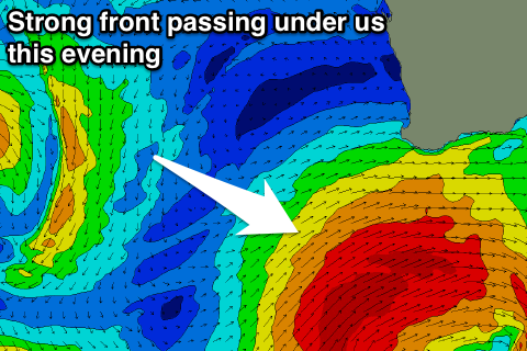
Unfortunately it's back to onshore winds tomorrow as a vigorous frontal system currently south-west of us clips the state, bringing with it a large increase in consistent SW groundswell. A fetch of gale to severe-gale SW winds will be projected towards us before pushing east through the Bight.
The swell should peak around 8-10ft during the afternoon across the South West with 2-3ft waves continuing around Perth and Mandurah.
 Moderate to fresh SW winds will create average conditions, easing into the afternoon opening up a few OK options.
Before we get a chance for lighter winds or offshores on Sunday, another approaching front will swing winds NW, increasing through the day. Perth and Mandurah should see early light NE breezes with a slight drop in size from Saturday.
As touched on in Wednesday's notes, this front won't have any major swell generating properties, with NW winds persisting Monday (N/NE early around Perth and Mandurah) with moderate amounts of swell (2ft on the metro beaches).
Tuesday looks no better as the surf eases along with persistent onshore winds.
Mid-week a new moderate to large sized W/SW groundswell is due, but this may be contaminated by local windswell.
A strong and elongated mid-latitude frontal progression moving through the southern Indian Ocean through the weekend should produce a good W/SW groundswell for Wednesday, coming in at 8ft+ across the South West and 3ft on the sets further north.
This system will actually break down before approaching us early next week, taking the form of a broad mid-latitude low and with this we'll see a strong fetch of S'ly winds projected up past our coast, generating some S/SW swell in the mix. Winds will also be poor and from the S/SW possibly tending more variable on the backside of the swell and storm Friday, but more on this Monday.
Longer term more mid-latitude stormy activity is expected next weekend, possibly settling down the following week, but more on this Monday. Have a great weekend!

