Large swells and onshores persist
Western Australia Surf Forecast by Craig Brokensha (issued Wednesday 2nd August)
Best Days: Perth and Mandurah Friday morning
Recap
Large W/SW groundswell filled in across all locations yesterday with poor conditions at exposed breaks across the South West but clean options in protected breaks, still with plenty of size. Mandurah and Perth were cleaner with 3-4ft sets, while today the swell has eased back a touch with light offshore winds from north of Cape Leeuwin.
This week and weekend (Aug 3 - 6)
This morning's window of offshore winds is only brief with an approaching frontal system from the west-southwest expected to bring onshore W/NW tending SW winds too all coasts from dawn tomorrow.
Today's swell will ease further, but a large new long-period SW groundswell should build later in the day, peaking Friday across the state.
The front linked to this swell is now forecast to push up and into us tomorrow, bringing with it an increase in stormy SW swell ahead of the groundswell proper. Margs looks to build to stormy 8ft later tomorrow with 2-3ft waves further north.
 The groundswell should peak in the 10ft+ range across the South West Friday with 3ft waves further north but with no let up in the onshore winds. A fresh to strong W/SW tending W'ly breeze will spoil the South West, while Perth should see more variable tending light offshore winds.
Into the weekend, onshore W/SW winds are due across all locations through the morning, easing a little and tending more W/NW ahead of another approaching cold front.
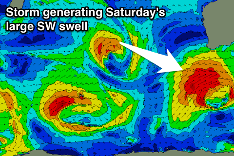
A large new SW groundswell will also be in the water Saturday, generated by a strong polar front firing up on the tail of the system moving through tomorrow.
A fetch of gale to severe-gale W/SW winds will be generated directly south-west of us, producing a large SW swell keeping Margs up around 8ft+ all day, with 2-3ft waves around Mandurah and Perth.
Unfortunately as touched on above, the approaching front Saturday will create average conditions, with it pushing closer Sunday creating fresh W/NW tending W/SW winds as the SW groundswell eases away.
The front will fail to have any real strength and with this there's no decent swell to follow in behind it Monday as onshore winds persist from the W/NW.
Longer term a strong mid-latitude front is expected to generate another large W/SW groundswell for mid-week but winds look to create poor conditions yet again. We may see the run of onshores ending into Sunday week, but more on this Friday.


Comments
Unreal conditions across Perth..
You called this ages ago craig .
Thats forecasting !
Cheers Clam, enjoy looking at wider climate factors affecting the surf for certain regions.