Oversized onshore swell tomorrow, cleaner Friday morning
Western Australia Surf Forecast by Craig Brokensha (issued Wednesday 12th July)
Best Days: Friday morning, Monday morning
Recap
All coasts saw a N/NE breeze yesterday morning but this limited surfing options with the small swell. Today stronger onshore winds have moved in with a mix of building windswell and stronger groundswell this afternoon.
We should see the South West reaching 6-8ft across exposed breaks this afternoon with 2-3ft of groundswell around Perth but with no let up in the onshore breeze.
This week and weekend (Jul 13 – 16)
Today's strong onshore winds are linked to the secondary stronger and more vigorous polar frontal progression pushing into the state.
This progression has aimed a fetch of severe-gale winds towards us, and a larger SW groundswell will result for tomorrow.
We should see the South West exposed reefs coming in at 10-12ft+ with 3ft+ waves around Mandurah and Perth, easing back through Friday from 8ft and 2-3ft respectively.
Unfortunately winds look to remain onshore across all coasts tomorrow with a fresh but easing SW breeze, but Friday looks much better with light morning E/NE offshore winds across all locations, tending N/NW through the day with an approaching front.
 Friday's freshening N/NW'ly will be linked to a pre-frontal NW fetch moving in from the west, but this isn't expected to bring any new swell for Saturday.
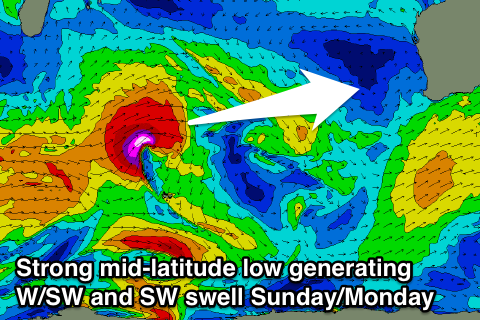
Into Sunday though a mix of building SW and W/SW groundswell are due, produced by an intense mid-latitude low developing south-east of Madagascar, traversing east through the Indian Ocean and then stalling off our south-west slightly Sunday.
We'll see SW swell building from the system stalling to our south-west on Sunday, with increasing surf to the 8ft range across Margs into the afternoon but with fresh to strong SW winds.
Perth and Mandurah should build to 2-3ft and they'll also see the onshore winds.
Into Monday the SW swell will ease, but some long-range W/SW groundswell from the early stages of the low will be in the water, with inconsistent sets easing from 6-8ft around Margs and 2-3ft in Perth with light offshore winds. We'll confirm this Friday though.

