Large powerful swells on target
Western Australia Surf Forecast by Craig Brokensha (issued Monday 5th June)
Best Days: Thursday, Sunday morning, Monday morning, Tuesday and Wednesday only for experienced surfers.
Recap
OK waves for keen surfers across the coast yesterday with a bit of swell during the morning and freshening NE winds.
Today wind swung back offshore across all locations along with a new building W/SW groundswell. This swell should continue to kick strongly this afternoon, reaching 10-12ft+ by dark across the South West and 2-3ft further north.
Winds are remaining favourable as well, so keep an eye on the cams for an afternoon paddle.
This week and weekend (June 8 – 11)
This afternoon's large and strong kick in W/SW groundswell is expected to peak overnight, easing back from the 10ft range on the sets tomorrow across the South West and 2-3ft in Perth.
Conditions will be great at locations that love NE winds, with a fresh E/NE tending NE breeze due tomorrow, less favourable from the N/NE tending N'ly Friday as the surf continues to ease.
As talked about on Monday, an inconsistent new W/SW groundswell is due over the weekend, building Saturday afternoon and peaking Sunday.
This swell was created by a strong polar frontal progression south-east of South Africa and should provide good 6-8ft+ sets across the South West with some more consistent and slightly smaller mid-period swell in the mix. Perth is due to offer fun 2ft to occasionally 3ft sets. Winds are still a little undecided with the models diverging regarding a small low moving in from the west. If we're lucky this system will clear quickly leaving offshore winds Sunday, but we'll have to review this Friday.
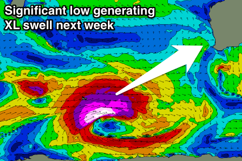
Our attention then turns to the XL swell event due next week.
 Currently a very strong storm is generating very large surf to South Africa, and the remnants of this system are expected to move into the Southern Ocean, re-intensifying in the Heard Island region this weekend.
Current forecasts have a significant low forming, possible reaching the requirements of a 'bombing low'.
A broad fetch of severe-gale W/SW winds will be generated with stronger core winds in the storm to hurricane-force range.
This low will project slowly east through our south-western swell window before weakening, only to spawn a secondary strong and more northern front, moving over the active sea state.
This will result in the production of an XL swell event for the WA coastline, with an initial long-period pulse of SW groundswell Tuesday followed by a reinforcing swell Wednesday.
At this stage we're looking at surf in the 15ft+ range across Margaret River (larger at offshore bommies) and 3-5ft waves further north. A ridge of high pressure will help create light offshore winds and clean conditions but check back Friday for a closer look at this impressive swell event.


Comments
Cape Nat buoy has really spiked and there were solid sets on dark. Photos from Hippo.
4.3m 18sec currently on nat buoy
http://www.transport.wa.gov.au/imarine/naturaliste-tide-and-wave.asp