Large SW groundswells, clean north of Margs
Western Australia Surf Forecast by Craig Brokensha (issued Monday 22nd May)
Best Days: Perth and Mandurah Tuesday morning, Thursday morning, Friday morning and Saturday morning, protected spots in the South West Saturday and Sunday mornings
Recap
Poor largish and onshore waves Saturday, clean around Perth with early light offshore winds and 2ft waves. Sunday saw larger stormy waves across all coasts and no decent quality.
This morning the swell has eased back to a smaller but onshore 4-5ft in the South West while Perth and Mandurah saw cleaner conditions with easing 2-3ft sets.
This week and weekend (May 23 – 28)
Unfortunately the South West will be plagued by onshore winds this coming forecast period as the storm track sits far enough north to impact the Margaret River region, but south enough for more variable and favourable winds around Mandurah and Perth.
Today's swell will continue to ease into tomorrow, with leftover 1-2ft sets north of Margs with early variable tending E/NE winds, while Margs will be onshore with a moderate W/SW breeze.
 Wednesday should see similar conditions with onshore W'ly winds in the South West and light offshores to the north, but the swell will be even smaller early.
Into the afternoon a slight increase in new SW groundswell is due, but this will be overridden by a much stronger and larger long-period SW groundswell Thursday.
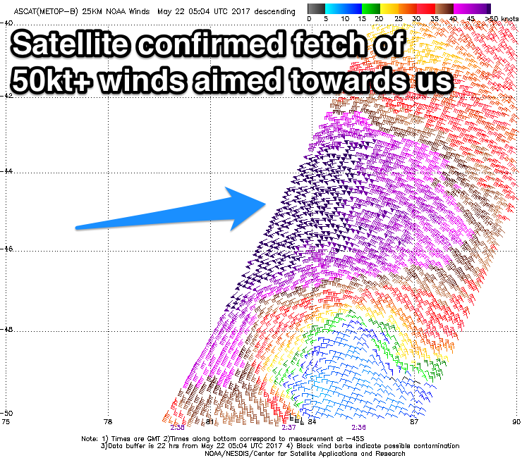
We'll actually see a mix of long-range SW groundswell from a vigorous storm firing up under South Africa late last week, while the closer-range and more consistent swell is being generated by a very intense and right low north-east of Heard Island.
We're seeing a fetch of storm-force W/SW winds being generated through our swell window, with the low due to slowly weaken while slowly growing in size as it moves east towards and then under us.
Both swells will arrive around the same time and we'll probably see some weird double ups at times, but a peak is due Thursday morning to a large 10ft+ in the South West and 2-3ft in Perth, easing slightly into the afternoon and down further Friday.
Winds on Thursday will freshen from the W/NW across the South West (lighter at dawn), creating average conditions while Perth and Mandurah should see early offshores.
Friday looks to then see SW winds (possibly variable early around Perth).
Into later Friday and more so Saturday another large long-period SW groundswell is due from a similar strong low forming north-east of Heard Island, maintaining its strength closer to the mainland.
This will likely result in a touch more size across the South West, coming in at 10-12ft, with 2-3ft waves around Perth.
Conditions will be clean again Saturday morning in Perth with an E/SE offshore, while to the south S/SW winds will limit the best waves to protected locations. As the swell eases, onshore winds look to linger around Margs, but there is a chance for a morning S/SE'ly if the low linked to the second large swell pushes off to the east quicker.
We'll have a closer look at this on Wednesday.

