Active period with large stormy swells for the weekend
Western Australia Surf Forecast by Craig Brokensha (issued Monday 26th September)
Best Days: Protected spots Wednesday, dawn Thursday
Recap
Poor onshore easing SW swell from 6ft+ across Margs Saturday morning, while Sunday was OK early in the South West with 4-6ft waves before a straight W'ly kicked in again.
Perth was a good clean 2ft+ Saturday morning, with smaller 1-1.5ft waves on Sunday.
Today the surf remained average in the South West with an onshore wind, while Perth was a lumpy 1-2ft with early offshores.
This week (Sep 27 - 30)
Tomorrow looks to be poor across all coasts as a cold fronts pushes up from the south, directing fresh W'ly tending S/SW winds into the state.
This will be with a new strong SW groundswell building across the region, generated by a strong mid-latitude front that's currently to our south-southwest.
With the front being a touch stronger than forecast last Friday we should see Margs building to a solid 8ft through the day, with 2-3ft sets in Perth but with those poor onshore winds.
Wednesday will be better but still less than ideal as the swell eases with gusty S/SE winds.
The swell will continue to ease through Thursday from 4-5ft+ in the South West, with 1-1.5ft waves max in Perth under an early NE breeze ahead of a strengthening NW'ly.
Winds will continue to strengthen into Friday as a vigorous mid-latitude frontal progression pushes into the state and this will kick up an afternoon increase in stormy windswell.
 Larger amounts of W/SW groundswell are then due into the weekend from the earlier stages of this mid-latitude frontal progression through the Indian Ocean.
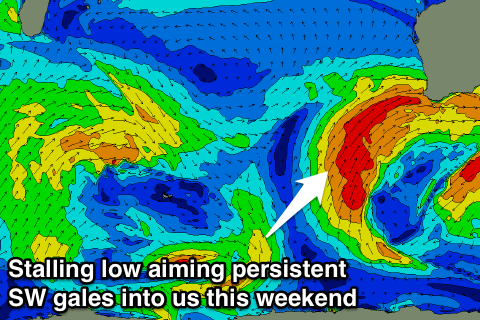
This will be the start of a very large onshore run of swell from Saturday through until Monday next week as a broad low pressure system develops and stalls over us through the weekend.
Flurries of SW gales will be slammed into us, generating stormy XXL swell in the 15ft range across the South West, with 4ft waves around Perth. Conditions will be a mess though with no respite until Tuesday next week around Perth, maybe Thursday for Margs. More on this Wednesday though.


Comments
How big will the next weekends coming swell be in once it gets up to Indo Craig?Enough for the Outside corner ?
Bigger than 15ft on sw bomboras surely
Probably just, it's all mostly mid-period stormy energy and a total mess. No major wind strengths to push it to that consistent 20ft range in my opinion.