Easing surf with northerly winds, good new swell for Friday
Western Australia Surf Forecast by Craig Brokensha (issued Monday 1st August)
Best Days: Tuesday morning, Thursday morning, Friday
Recap
Building large stormy waves through Saturday with strengthening onshore winds, while Sunday was XXL and unruly across all but super protected spots, which offered options later in the day across the South West as winds tending more S/SW.
The Cape Naturaliste buoy hit 8m, while Rottnest was incredible too with Significant Wave Heights maxing just over 7m.
Today winds swung offshore with a ridge of high pressure quickly sliding in from the west, with improving XL waves across the South West and 3-5ft surf further north. Conditions should remain great into the afternoon as winds tend more variable and the swell eases further.
This week (Aug 2 - 5)
With the high pressure system moving in so quickly today we'll see winds swing northerly tomorrow, with an early NE tending fresher N'ly breeze due (N/NE around Perth). Our oversized W/SW groundswell will ease back further, dropping from 6-8ft+ in the South West and 3ft on the sets around Perth.
Wednesday then looks poor with a reinforcing SW groundswell steadying the easing trend but along with strengthening N/NE tending N/NW winds.
 In the wake of this front a weak mid-period increase in W/SW swell is due, but not above 4-6ft in the South West and 1-2ft in Perth Thursday morning, easing into the afternoon. Conditions will be better for this swell with a morning variable breeze, increasing from the W/SW into the afternoon.
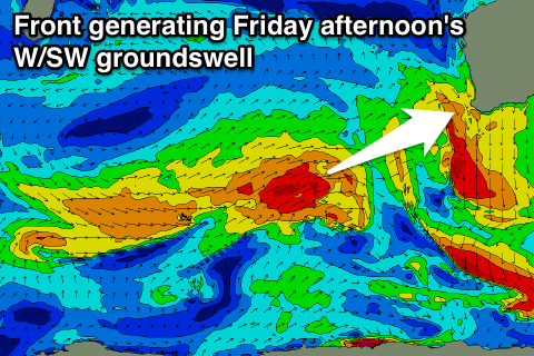
A better W/SW groundswell is due to build Friday, generated by a short-lived but strong mid-latitude front pushing towards us through the middle of the week. Margs should build to a good 6ft to occasionally 8ft into the afternoon, with 2ft+ waves in Perth later, easing back from 6ft and 2ft respectively Saturday morning.
Conditions look good most of the day with an offshore E/NE tending variable breeze due across most regions, while Saturday looks average with a NE tending NW breeze.
A couple of further larger pulses of W/SW groundswell are due into Sunday and Monday next week, generated by a relatively weak but persistent flurry of fronts pushing closer to us through the end of the week.
The back to back action will produce a series of large W/SW groundswells, building Sunday and peaking Monday/Tuesday in the 10-12ft range across the South West (3-4ft Perth) but with onshore winds. We'll have another look at this Wednesday though.

