Nothing special until Thursday and Friday
Western Australia Surf Forecast by Craig Brokensha (issued Monday 18th April)
Best Days: Protected spots tomorrow morning and Wednesday morning, Thursday, Friday, Saturday morning
Recap
Early Saturday fell in between swells with clean 4ft waves ahead of a good increase in new SW groundswell up to the 6ft range on the sets. Conditions were clean all day with fresh offshore E'ly winds, tending variable into the afternoon. Perth and Mandurah started tiny with some small surfable sets into the afternoon.
Sunday was poor with a drop in swell and onshore winds.
Today onshores continued with a smaller swell leaving no decent options for a surf at all.
This week (Apr 19 - 22)
Tomorrow's inconsistent SW groundswell is still on track, with exposed breaks due to build to an infrequent 4-5ft+ through the afternoon, easing back slowly through Wednesday. Perth isn't due to see any major size over 1ft+.
Conditions will improve for tomorrow morning with a S/SE breeze across the South West, tending S/SW into the afternoon, while Wednesday looks to play out similar, which isn't ideal.
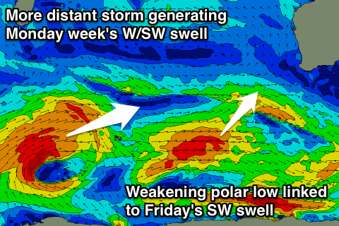
 Our stronger SW groundswell for later Thursday and now more so Friday is still on the cards, with a strong and distant polar frontal progression over the weekend west of Heard Island producing a fetch of gale to severe-gale W/SW winds.
Thursday will likely be around the 4-5ft range as a shorter-range SW swell fills in from the weakened front pushing south-west of us over the coming days. Conditions will be clean with an offshore E/SE wind, tending S/SE into the afternoon.
The groundswell should arrive later in the day but peak Friday morning to an inconsistent but good 5-6ft+ across the South West, with 1-2ft sets around Perth. Offshore E/NE winds will create clean conditions, ahead of variable breezes into the afternoon as the swell drops.
This weekend onwards (Apr 23 onwards)
Friday's swell will continue to ease back through Saturday from the 3-5ft range in the South West, but you'll have to get out early as a morning NE breeze is due to swing more NW through the day.
Saturday's NW breeze will be linked to a deepening mid-latitude low approaching us, but the models are unsure about the strength and intensity of this system.
Latest updates have it producing a fetch of severe-gale to storm-force SW winds into the South West, producing a large stormy building swell later Sunday and into Monday. This will be mixed with a moderate sized and inconsistent long-range W/SW groundswell to a smaller 4-5ft+ but check back here Wednesday for more info on this.


Comments
Wow Craig, SB models are resembling an Olympic ski jump Sunday night.... they do always seem to be a bit more generous than SN so it will be interesting to see what's on your menu come Wednesday given that SB is only calling Friday to be more in the 3 to 5 foot range?
We've also got a similar pulse, captured fetch scenario, but models still in disagreement. Expect that to drop back next update..
Errr! It's a bit like my bank acn , balance is "x "but the available is "y"
Craig , as far as sea surface temps , land temps and currents ,what are the long range forcasts for the Indian Ocean this winter. Not all but some cockies out in the wheat belt are betting on a wet one? How might this pan out for us shark fuckers?