Building swell with morning offshores tomorrow, average Sunday and Monday
Western Australia Surf Forecast by Craig Brokensha (issued Friday 15th April)
Best Days: Saturday morning, Tuesday and Wednesday mornings, later Thursday, Friday
Recap
Onshore winds and building levels of swell into the afternoon yesterday across the South West, while Perth and Mandurah were cleaner but tiny.
Today a new inconsistent W/SW groundswell mixed in with a smaller and more consistent short-range mid-period SW swell has offered mixed 4-5ft+ waves across the South West and 1-2ft sets further north. Conditions are improving as well with stiff offshore winds, swinging more E'ly through the day.
This weekend and next week (Apr 16 - 22)
This morning's mix of W/SW and SW swells are due to ease back through the afternoon, further into early tomorrow morning, but a new good SW groundswell is due to arrive through the mid-morning, building to a good 4-6ft across the exposed reefs in the South West. Perth isn't due to see much size of this swell, with infrequent 1-1.5ft sets.
Conditions are looking good but tricky with a fresh and gusty E/NE wind at dawn, tending NE through the morning and then N'ly into the afternoon and evening. With this in mind, try and surf through the morning.
Onshore W/NW winds are then due into Sunday as the SW swell eases, smaller into Monday with lingering onshore SW winds, easing through the day.
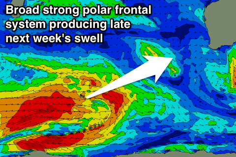
Into Tuesday an inconsistent but moderate sized SW groundswell pulse is due, with it being generated by a strong polar frontal progression forming west of Heard Island.
This system isn't looking as strong as it was forecast to be Wednesday, but a secondary system firing up behind it does, generating a larger and slightly more consistent swell for later Thursday and Friday.
 Firstly though Tuesday's SW swell should provide inconsistent 4-5ft+ sets across the South West (nothing above 1ft+ in Perth) with better S/SE-SE winds through the morning.
Similar conditions are due Wednesday as the swell eases, while offshore E/SE winds are on the cards Thursday as the stronger swell kicks, reaching 6ft by dark and easing from a 6ft+ Friday morning under E/NE offshores. We'll confirm this Monday though, have a great weekend!

