Small fading surf with favourable winds, significant swell next week
Western Australia Surf Forecast by Craig Brokensha (issued Wednesday 23rd March)
Best Days: Every day over the coming period across swell magnets in the South West
Recap
Plenty of swell around 4-5ft but bumpy conditions across the South West yesterday morning, with tiny 1-1.5ft peaks further north.
Today the swell was around the same size, and early SE winds have since shifted more E/SE across the South West, creating cleaner conditions.
This week and weekend (Mar 24 - 27)
Good conditions but easing surf is due over the coming days, with similar gusty E/SE offshores tomorrow morning. A reinforcing SW groundswell should keep 3-5ft sets hitting exposed breaks, dropping back through the afternoon and further from 3ft+ Friday morning under moderate to fresh E/SE winds.
Perth and Mandurah will remain tiny but clean.
The S/SW swell for the weekend isn't looking as favourable with the frontal activity forming later in our swell window than ideal.
In saying this, exposed breaks around Margs shouldn't drop below 3ft+, with favourable offshore E/SE winds each morning.
Next week onwards (Mar 28 onwards)
The surf will bottom out into early next week with nothing of significance due at all. Morning E/SE winds should continue, favouring swell magnets in the South West for desperate surfers.
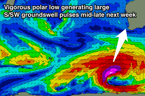
Of greater importance is the formation of a broad, elongated and slow moving polar low to our south-southwest early next week.
 This system will generate back to back fetches of severe-gale to storm-force SW winds through our southern swell window, with a couple of large S/SW groundswell pulses due.
The first should kick strongly Wednesday afternoon ahead of a peak Thursday morning in the vicinity of the 8-10ft range across Margs. Perth looks to see surf in the 2ft+ range, but we'll have a closer look at this on Friday.

