Fun S/SW swell across exposed breaks from Friday
Western Australia Surf Forecast by Craig Brokensha (issued Wednesday 16th March)
Best Days: Friday mid morning onwards, Saturday, Sunday morning, Tuesday morning keen surfers, Wednesday morning onwards
Recap
Workable waves across the South West yesterday morning with a light onshore and crumbly 3-5ft sets, while further north conditions were also workable but with no decent swell.
Today a stiffer onshore wind and drop in size is leaving no decent options.
This week (Mar 17 - 20)
A small kick in SW swell is due tomorrow, but to no major size, with inconsistent 3ft sets due into the afternoon.
Friday's better S/SW groundswell has been downgraded slightly as a result of the polar frontal progression generating the swell not being quite as strong as forecast on Monday.
We should still see a lift in surf, but only to the 4-5ft range across the South West into the afternoon, tiny and only to 1ft around Perth.
The swell will then ease back overnight, dropping from 3-4ft+ or so Saturday, down further from 3ft Sunday morning.
Conditions are looking to improve over the coming days with a SE tending S/SE breeze tomorrow and fresh E/SE tending S/SE winds Friday. Saturday should see slightly straighter E'ly offshores before sea breezes kick in, with SE-S/SE winds Sunday.
Next week onwards (Mar 21 onwards)
From the weekend, a flurry of strong but late forming polar storm activity will develop across the southern extent of our swell window.
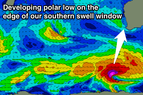
 The first system will be an intense polar low firing up really late to our south-southwest, aiming a fetch of severe-gale to storm-force W/SW winds on the edge of our southern swell window.
Some long-period S/SW groundswell should spread up radially off this source, building Monday afternoon to an inconsistent 3-5ft holding around 4-5ft Tuesday morning.
This swell will be replaced by a building short-range S/SW swell as a strong cold front pushes up and into us through Sunday and Monday.
An afternoon increase to 3-5ft or so is due Tuesday, with a peak Wednesday morning to 4-6ft, easing back through Thursday and Friday morning.
Perth isn't expected to see any size off the S/SW groundswell, with the S/SW swell for Tuesday afternoon/Wednesday coming in at a better 1-2ft.
An onshore S/SW change is due Monday with OK SE winds through Tuesday, better but strong offshore from the E/SE Wednesday. Offshore E/SE winds should then persist into the end of the week.
Longer term another dose of S/SW groundswell is due late week and into the weekend from strong polar frontal activity firing up towards the Bight, but we'll have another look at this Friday.

