Small swells continue, biggest Monday and Tuesday
Western Australia Surf Forecast by Craig Brokensha (issued Wednesday 17th February)
Best Days: Saturday morning in the South West, Tuesday and Wednesday mornings in the South West
Recap
Easing swell back from 3-4ft yesterday across exposed breaks in the South West with strong offshores, best through the middle of the day as winds eased ahead of afternoon sea breezes.
Today was even smaller with early offshores ahead of a gusty S/SW change.
This week and weekend (Feb 18 - 21)
A slight increase in new SW groundswell is due tomorrow with 3ft sets due across the South West, with a slightly better increase filling in Friday due to provide 3-4ft waves (0.5-1ft around Perth and Mandurah).
Winds aren't due to be the best tomorrow with fresh and gusty SE'ly breezes, better from the SE-E/SE Friday morning, tending SE into the afternoon.
Much better conditions are due Saturday morning as the swell eases from 3ft or so under fresh E/NE winds and afternoon sea breezes.
A low point in swell activity is due Sunday morning with light winds, ahead of a new inconsistent long-period SW groundswell later in the day.
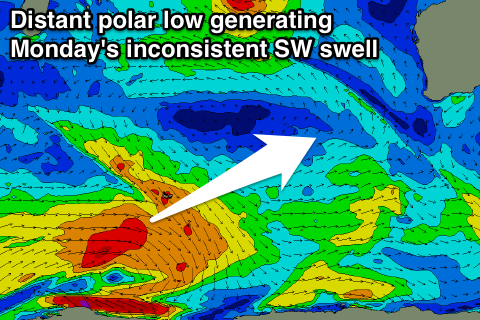
This swell will be generated by a strong but distant polar low that's developed south-east of South Africa and south-west of Heard Island, generating a fetch of severe-gale W'ly winds along the polar shelf.
 The low will weaken this evening leaving the swell to travel towards us, peaking Monday, but a secondary closer-range polar front firing up on the back of the swell should produce another good SW pulse for Tuesday.
The first inconsistent pulse should offer 4-5ft waves across the South West, becoming more consistent Tuesday morning and peaking around 4-5ft+.
Unfortunately a fresh S'ly wind is due Monday with the first pulse, tending more SE Tuesday and holding Wednesday.
Longer term some new S/SW groundswell is due late week with favourable winds from a strong polar frontal progression developing late in our swell window during next week, but more on this Friday.
One final note, Tropical Cyclone Uriah is still not expected to generate any meaningful swell for us due to the fetch on the north-east flank of the cyclone in our swell window being too small and isloated.


Comments
What swell and wind is due for Perth/Mandurah on Monday/Tuesday?
Looking at E/SE winds but not much size with 1-1.5ft sets.
When are there going to be waves ?
SA, later next week/weekend, WA not for a while still..
The el nino continues
Lol its like asking a shaper about a board...