Average outlook with limited windows of clean conditions
Western Australia Surf Forecast by Craig Brokensha (issued Friday 4th December)
Best Days: Tuesday morning, Friday morning
Recap
Small to tiny and average waves yesterday morning ahead of a late kick in new SW groundswell which has peaked today in the 4-5ft range across the South West but with average winds. Perth and Mandurah didn't offer any real size and conditions were also less than desirable.
This weekend and next week (Dec 5 - 11)
Not much to get excited about this weekend with a drop in swell through tomorrow and further Sunday with increasing S/SW winds tomorrow, stronger from the S/SW (SW in Perth) Sunday.
Into Monday a small acute S'ly swell may be seen across south swell magnets in Margs, from a weak low stalling off the tip of the state, but winds will remain poor and onshore from the S/SW.
Our inconsistent but good SW groundswell due for later Monday and more so Tuesday across the coast is still on track, with a vigorous polar low forming south-east of South Africa mid-week, before weakening while slowly pushing east.
Margs should peak Tuesday morning in the 5-6ft range across exposed breaks, with the chance of the rare bigger bomb. Perth isn't due to see much above a very infrequent 1-2ft.
 Variable winds are still on the cards for Tuesday morning with glassy but likely lumpy/wobbly options across Margs, cleaner to the north before sea breezes kick in.
The swell should slowly tail away through Wednesday and further Thursday with winds looking a little dicey but likely light from the S/SE each morning.
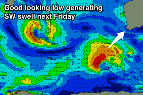
Into the end of the week a good fun consistent SW groundswell is due from a strengthening and favourably tracking polar low from the Heard Island region up towards us.
A fetch of W/SW gales should produce a moderate to large sized SW groundswell for Friday to the 5-6ft+ range around Margs and 1-2ft up in Perth with SE winds.
Longer term, the outlook remains pretty mediocre, but check back here Monday for an update on this. Have a great weekend!

