Average period ahead, best over the coming days
Western Australia Surf Forecast by Craig Brokensha (issued Monday 30th November)
Best Days: Tuesday and Wednesday mornings in the South West
Recap
Nothing special over the weekend at all with very small waves in the South West with average winds, tiny to flat to the north.
A slight kick in size was seen to 3-4ft across the South West this morning, building further this afternoon as average winds continued, while Perth and Mandurah struggled at 0.5ft.
This week and weekend (Dec 1- 6)
This afternoon's building SW groundswell should reach 4-5ft across the South West and 1ft in Perth, but this will be replaced by a new S/SW swell tomorrow from a relatively weak frontal system that's currently directly south of us.
This should keep exposed breaks in the South West kicking at 4-5ft tomorrow morning, with 1ft sets in Perth if we're lucky, easing back through Wednesday and further Thursday morning.
Winds will improve for the mix of swells tomorrow with an E/SE offshore, tending S/SE into the afternoon in the South West.
 Wednesday should see offshore E/NE winds ahead of afternoon sea breezes.
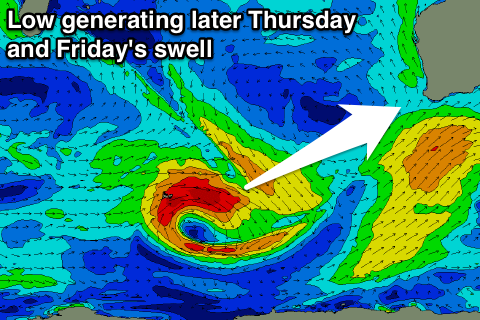
The next noticeable increase in swell is due to kick late Thursday across the South West, with it currently being generated by a small low in the Heard Island region. This low will track east while weakening this evening and tomorrow, with a small SW groundswell kicking late Thursday to 4-5ft+ across the South West, peaking overnight and easing from a similar size range Friday morning.
Perth is only due to see tiny 1ft+ waves Friday morning.
Unfortunately conditions will take a turn for the worse Thursday with increasing S/SW winds, and then S/SE to S/SW breezes Friday.
The weekend isn't looking much better as the swell eases with S/SE breezes Saturday and then onshore S/SW winds again Sunday.
Longer term there is a hint of some better groundswell on the way for early to mid-next week, but we'll have another look at this with more confidence on Wednesday.

