Solid swell but poor winds this weekend
West Australian Surf Forecast by Guy Dixon (issued Friday 11th September)
Best Days: Possibly late Sunday, Monday, Tuesday and Wednesday
Recap: Strong northwesterly winds labelled Thursday a lay day for the South West. The surf built from 4-5ft in the morning to a late 6ft+, however there were no decent options for a wave. It was the same story today with strong northwesterly winds spoiling the fun. We started off with 5-6ft sets this morning, building this afternoon to a solid 6-8ft.
As for Perth and Mandurah, the news was no better. Thursday saw a small 1-2ft swell which was ripped apart by gusty northerly winds, swinging through to west/northwesterly in the afternoon. There was no chance of a decent wave today either despite a bit more size on the cards. We have peaky, short range disorganised 2-3ft surf with no where to gain any protection.
This weekend (Saturday 12th - Sunday 13th):

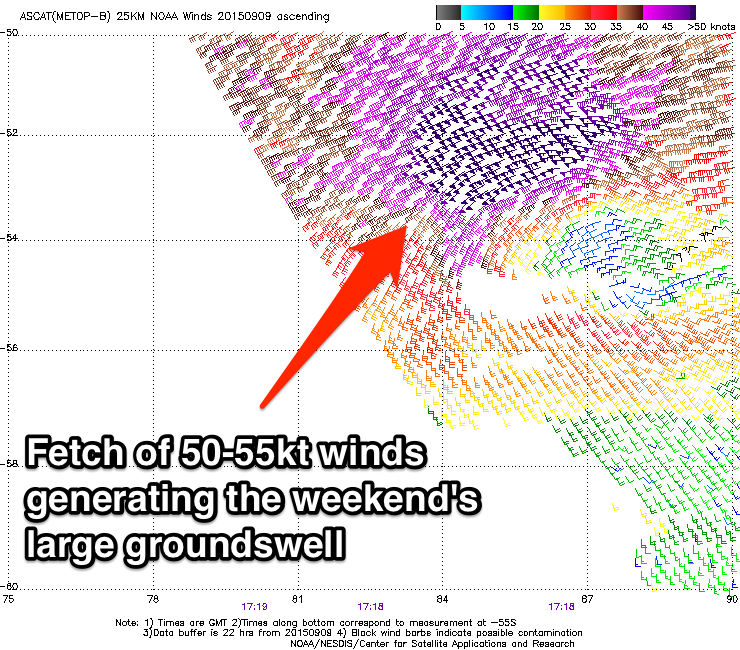
We have been following a strong system over the past week which is forecast to whip up a strong southwesterly groundswell due on Saturday. The satellite pass early Thursday morning observed core winds within a well aligned southwesterly captured fetch of 50-55kts.
We will see the fresh swell fill in across the South West on Saturday (although the periods aren’t quite as long as we were anticipating earlier in the week). The surf will build to a solid 10-12ft late in the day, likely peaking overnight. Perth and Mandurah should do well off this system in the size department as the northern flank of this system shows fetches that are well aimed to the Metro coasts. The surf should easily be in the 3ft range, with bigger sets considering there is already a large amount of wind swell energy in the water.
Sunday will see the surf ease back, but still remaining large maintained by a southwesterly trailing fetch working on an active sea-state. The surf should fade from around 8-10ft for the South West and holding in the 3ft range for Perth and Mandurah.
It’s looking like one of those typical weekends that we’ve seen too many times this season where you deliberate over winds to find the best opportunity of a terrible bunch.
Winds across the South West will be fresh/strong westerly early, gradually swinging through to south/southwest by dark. Perth and Mandurah will be under a fresh/strong west/southwesterly breeze first thing, tending southwesterly late. Quality will be low pretty much everywhere.
First thing Sunday, the South West will be under a fresh south/southwesterly breeze, as will Perth and Mandurah, but marginally lighter. Winds will ease and tend southerly across all coasts throughout the day, so this will be the best time out of the weekend to hit it at protected locations.
Next week (Monday 14th onward):
Looking at Monday, residents of the South West will wake to surf in the 6ft range while the Metro stretch will have faded back to around 1-2ft. By this stage, winds will have settled right down, with light south/southwesterlies early across the South West, tending light southerly and possibly variable late. Perth and Mandurah will see east/southeasterly breezes throughout the morning before a light southerly breeze increases into this afternoon.
A late period pulse will fill in generated by a poorly aligned northwesterly pre-frontal fetch moving over the Indian Ocean today. The most significant increase in size will be seen on Tuesday however, with the surf building to around 4-6ft across the South West. Perth and Mandurah won’t see much, with surf in the 1-2ft range.
Winds will be favourable across all coasts throughout the day with light easterlies early, tending light northeasterly in the afternoon for the South West and variable late for the Metro stretch.
The swell window for the remainder of the week looks fairly dormant with subtle ebbs and pulses of background energy keeping the surf between 3-4ft for until Thursday.
As for winds, Wednesday is looking good with moderate east/northeasterly breezes persisting throughout the day for Perth and Mandurah, similarly for the South West only lighter.
Models suggest a low to move locally on Thursday resulting in a gusty easterly breeze for Perth and Mandurah and a northeasterly breezes for the South West tending northerly in the afternoon. I’m inclined to take this situation with a grain of salt however (although there is fairly good model consensus this far out) as these systems like to dance around a bit before becoming locked in.
Friday will see a kick in size generated by a long lived westerly fetch which will traverse the Indian Ocean from well west of Heard Island south of WA on a long and low trajectory. We should see the surf jump to around 6ft+, and possibly further on Saturday.

