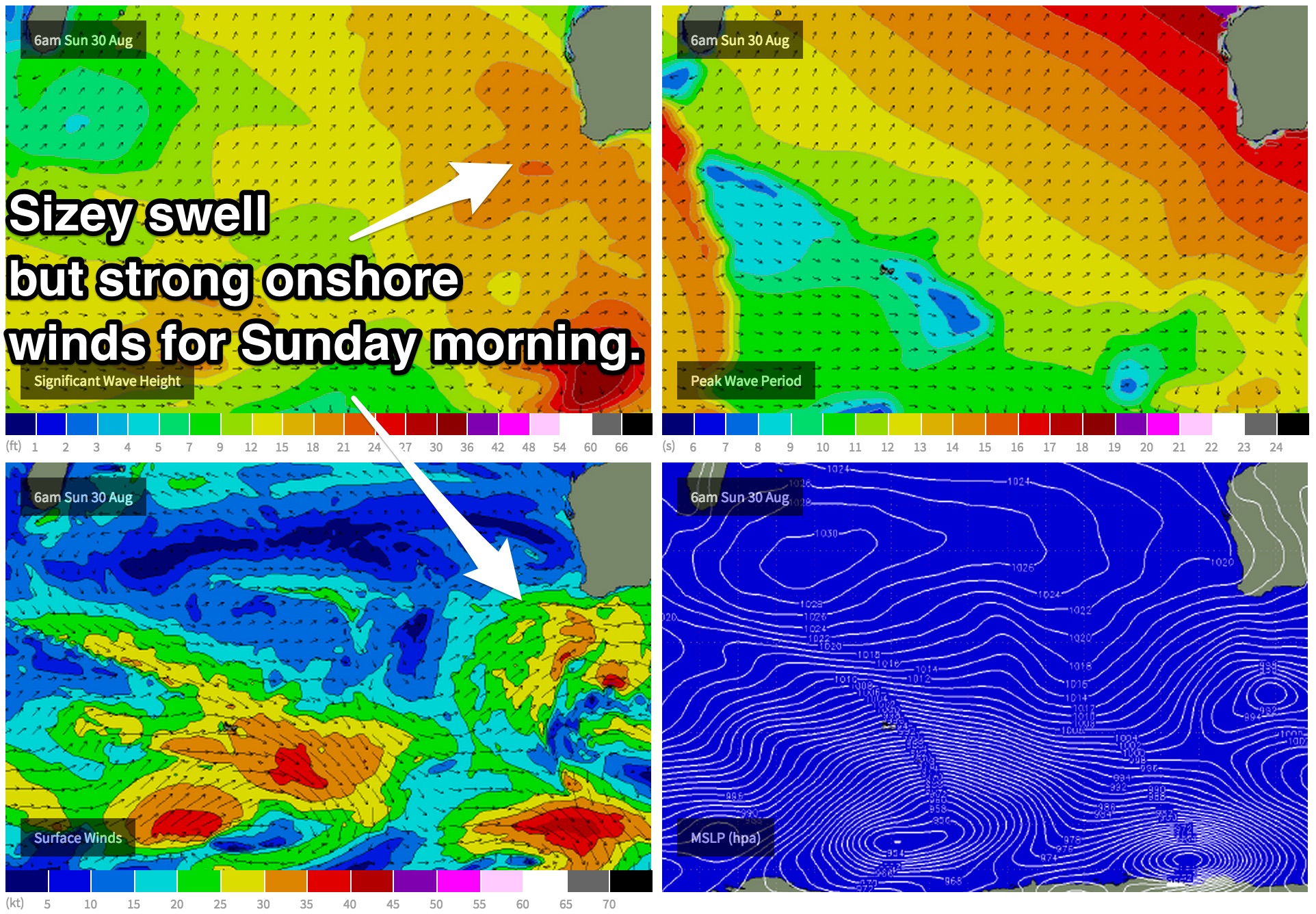
Not much but big wind blown conditions until mid-next week
West Australian Surf Forecast by Guy Dixon (issued Friday 28th August)
Best Days: Wednesday, Thursday
Recap:
Conditions were great on Thursday with solid 6ft surf across the South West with a few 8ft bombs thrown in for good measure. Light easterly winds were keeping everything in order making for a long day of epic waves. Further north, conditions were clean under light offshore breezes but the surf was lacking in the size department, maxing out at around 1-1.5ft.
The brief run of good surf came to an end today with fresh onshore winds wreaking havoc. The surf bumped up to around 5-6ft across the South West this afternoon, but conditions were already chopped up with no decent options on offer. Perth and Mandurah were offering 1-2ft peaks with variable/low quality under a light northwesterly breeze.
 This weekend (Saturday 29th - Sunday 30th):
The set up for the weekend remains largely the same as the previous forecast. A fresh pulse generated pre-frontal fetches preceding the system responsible for Sunday’s large swell will fill in over night this evening. As a result, Saturday will see the surf build into the 6ft+ across the South West with a few solid sets in the 8ft range by dark.
A main swell front generated by a long range system which we have been monitoring all week will begin to impact the South West overnight Saturday night. The bulk of this swell will fill in on Sunday morning and is looking pretty big. We should see 8-10ft surf across the South West with the odd 12ft set in the mix.
Metro beaches will build to around 2ft on Saturday and up to 2-3ft on Sunday. Gusty winds will also whip a short range wind swell which has the potential to provide a bit more size, but with poor quality.
The scenario for wind has improved slightly, but outlook still looks pretty bleak, with persistent fresh onshore winds and very few windows of opportunity.
Saturday will see fresh northwesterly winds from the word go right across the coast. Some models show a brief window of lighter northwesterly winds first thing across the South West, but I'm reluctant to even mention this because the window is so small (spatially and temporally) and there is only one model which supports this scenario, so don’t bank on it.
On Sunday, west/southwesterly winds will be fresh first thing, gradually easing throughout the day. Despite easing, the late session is likely to still be a write off with a whole lot of residual scarring on top. These gusty winds will also add an element of short range wind swell into the mix.
The outlook for the Metro beaches looks equally as disappointing, however winds look to ease right back for the late session on Sunday. Again, there will be a whole lot of scarring, chop, short wave energy and light onshore breezes, so it’s not going to be amazing.
Next week (Monday 31st - Friday 4th):
Monday will see a downward trend as the groundswell dissipates, however a trailing fetch of south westerly gales moving locally will maintain a shorter period, peaky day of swell in the 6-8ft range across the South West. Perth and Mandurah should also do well off this, with peaky short range westerly swell in the 2-3ft range for the start of the week.
Winds aren’t looking great however, fresh westerly over the South West and Metro beaches in the morning, tending south/southwesterly throughout the day. There might be the opportunity for a low quality wave at super protected spots late in the day when the winds are at their most acute southerly angle.
The swell window looks pretty dormant there after and the swell across should gradually fade across all coasts throughout Tuesday and Wednesday.
Tuesday will see moderate southerly breezes in the morning, easing in the afternoon. Metro beaches will be under a moderate south/southwesterly breeze first up, easing and tending more southwesterly throughout the late afternoon.
On Tuesday, we should see a northwesterly fetch of strong winds set up ahead of a front. This system is looking to provide a subtle period pulse late on Wednesday and into Thursday. The size off this system will be negligible for the South West but should provide a few 1-2ft peaks for Perth and Mandurah on Thursday.
Winds are looking good for Thursday, straight offshore at Metro beaches and becoming light in the afternoon. The South West will also be under an east/northeasterly flow, but the swell will have dried up and be back to the 3-4ft range by that stage.
Further Ahead:
There are indications of a stronger pulse for the weekend. We will go into more detail in Monday’s notes. Enjoy your weekend - sorry about the wind.

