Large weekend ahead, plagued by poor winds
West Australian Surf Forecast by Guy Dixon (issued Wednesday 26th August)
Best Days: Thursday, Friday, Tuesday
Recap:
The South West has a had a great couple of days of waves. Yesterday saw clean surf in the 6ft+ range under moderate/fresh easterly breezes tending northeasterly in the afternoon. This morning saw a similar set up with solid 6ft surf under light/moderate easterly breezes, however the surf has since deteriorated under freshening northerly breezes.
Further north, Perth and Mandurah saw the surf build throughout yesterday afternoon picking up clean peaks nudging 2ft. Today, light northerly winds are blowing, but remain light enough for conditions to remain clean with small 1-2ft peaks filling in.
This week (Thursday 27th - Friday 28th):
There isn’t much fresh swell to speak of until the end of the week. Thursday will see the surf fade back to around 5-6ft under moderate northeasterly breezes (possibly east/northeast for a period early) easing late across the South West. A small cut-off low will pass to the west of the mainland on Thursday afternoon, however the westerly fetches along the northern quadrants of this system are hardly broad enough, strong enough or prolonged enough to generate any swell worth mentioning. Perth and Mandurah will pick up 1-2ft of short range wind swell under easing east/northeasterly winds which will become light and variable in the afternoon but that’s about it.
A fresh pulse of groundswell will fill in on Friday morning, bumping the surf up to the 6ft+ range across the South West, with little to no notable increase in size for Perth and Mandurah which will continue to see surf in the 1-2ft range.
Friday’s winds are fairly subject to change as they’re highly dependent on the timing/movement/position of the cut-off low. At this stage, the South West is likely to be under a moderate southwesterly flow first thing, easing throughout the day and gradually tending west/northwesterly. Meanwhile, Perth and Mandurah are set to be under a light onshore flow for the best part of the day, with the chance of a light east/northeasterly breeze in the early hours of the morning.
 This weekend (Saturday 29th - Sunday 30th):
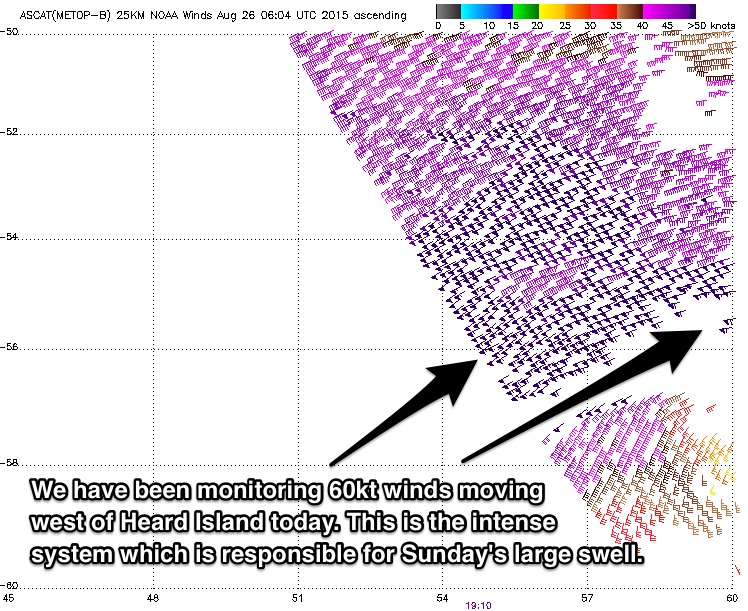
A pulse generated by pre-frontal activity (ahead of the system which is generating Sunday’s large swell) will impact the South West on overnight Friday night into Saturday providing 6ft+ for much of Saturday.
As for the large swell which is expected to follow soon after, the long period forerunners are now only likely to meet the mainland late on Saturday, with the surf building to a strong 8ft.
The bulk of the swell will move through on Sunday. We should see the surf kick to around 8-10ft with a few 12ft set thrown in for good measure, but the entire weekend is still likely to be plagued by gusty onshore winds.
Without getting into too much detail, Saturday is a pretty much a write off with fresh northwesterly winds tending southwesterly in the afternoon. Sunday isn't much better, with a similar set up of fresh northwesterly winds tending southwesterly, potentially gusting stronger in the middle of the day.
As for the Metro beaches, this swell event will provide an underlying 2-3ft ground swell, however this will largely be overshadowed by a short range wind swell which is likely to provide 2-3ft of peaky poor quality surf.
There is the possibility of a brief window of opportunity for a wave first thing on Saturday morning, but don’t expect anything special. It will merely be the best bad bunch. Otherwise, the remainder of the Saturday is looking at gusty northwesterly breezes tending westerly in the afternoon and northwesterlies tending southwesterly on Sunday. No real options available.
Next week (Monday 31st onward):
There are no significant indications of fresh ground swell early next week so we are likely to see the swell fade to around 6-8ft on Monday and further to 4-6ft on Tuesday across the South West.
Winds will continue to be fresh southwesterly for much of Monday right along the coast with no real opportunity for a half decent wave. It looks as though Tuesday has the best chances of winds easing and becoming workable.
The South West will be under a light/moderate southwesterly flow first thing, tending westerly and becoming light in the afternoon. Metro beaches will be light east/northeasterly tending variable thought the afternoon.
Longer term there is the indication of a moderate-large swell for Thursday, but we'll look into this more in Friday's notes.


Comments
what do you reckon about winds on friday between walpole and albany guy? models are showing a lot of variation in terms of winds but looks like a good system for that part of the state
I reckon Friday is a go for that part of the world. It's looking like winds will be freshening north/northwesterly for the best part of the morning, tending westerly in the early afternoon at Walpole, obviously later for Albany as the change maves from west to east. There is some model variation as you say though. A couple of models have a north/northeasterly flow and a slightly earlier change, but even then, the morning looks promising to me.
I'll have another look this evening with the late model update also.
Most models are showing light northerly breezes at day break, tending more NNW by about 9am-ish before adopting a northwesterly breeze by early afternoon. It looks as though the morning session is a go, but the earlier the better, and the closer to Albany the better.
Definitely worth taking the day off to make the trip down then. Don't have access to a computer atm but last time I checked the gfs model was showing the wind going a little s first thing Sunday what do ya think guy?
Fresh/strong WSW winds first thing Sunday morning for the Walpole stretch, more WNW for the Albany stretch. Only for the protected spots that's for sure.