Finally some workable winds late on the weekend and into next week
West Australian Surf Forecast by Guy Dixon (issued Friday 21st August)
Best Days: Sunday, Tuesday, Wednesday
Recap:
Persistent and gusty onshore winds have been wreaking havoc over the past few days right along the WA coast. Wednesday saw shocking conditions with small, choppy surf in the 3-4ft range for the South West, while Perth and Mandurah endured choppy 2ft slop. Thursday saw the swell bump up a touch to the 6ft range across the South West and 2-3ft for Metro beaches, but again fresh southwesterly breezes spoiled the fun creating turbulent and choppy conditions.
This weekend (Saturday 22nd - Sunday 23rd):
A long range but particularly inconsistent southwesterly ground swell is likely to fill in across the South West on Saturday. Also in the mix will be a short range wind swell generated by the cut-off low which is passing over the South West as we speak. The fetch from the cut-off system is poorly aligned for the South West, so the surf should only be in the 4-6ft range. Conditions are likely to be pretty terrible with a strong and gusty southerly flow racing up the coast. Options will be limited to only the most protected southern corners.
As for the Metro beaches, there will be a window of light variable winds in the morning before that gusty southerly breeze sets in with surf in the 2-3ft range off the back of the cut-off system.
Sunday will see a small period pulse in the morning but is not expected to add any significant size. Instead, this will merely slow the easing trend, with surf fading to 4ft across the South West and 1-2ft for Perth and Mandurah. On the plus side, winds are looking much more manageable, with the Metro beaches under a light/moderate and workable southeasterly flow easing into the afternoon. The South West should also be able to find some options under a moderate southeasterly breeze for the best part of the day.
Next week (Monday 24th - Friday 28th):
Monday will see a fresh long period swell fill in across the South West, however there looks to be very little size with it. The surf is likely to fade further to an inconsistent 3-4ft with Perth and Mandurah winding back to 1ft. Winds will be favourable all day with light easterly winds right along the coast for those of you who wish to have a punt on the dregs.
On Tuesday, we should a kick in size off a long range frontal progression moving from west of Heard Island. The surf should jump into the 6-8ft range across the South West. Due the the swell direction, Perth and Mandurah shouldn’t pick up much from this pulse apart from a few 1-2ft peaks.
Winds will be light/moderate east/northeasterly in the morning for the South West, tending more northerly into the afternoon. The Metro stretches will see a similar fate, however as winds turn northerly, they are also likely to ease allowing conditions to remain alright for the afternoon session.
A second system following closely behind will generate a second pulse for Wednesday keeping surf in the 6ft+ range across the South West and 1-2ft for Perth and Mandurah. The set up for winds is looking similar to the day before with northeasterly breezes first off for the South West, tending north/northeasterly in the afternoon, and northeasterly breezes becoming light/variable-northerly in the afternoon for the Metro beaches.
The surf will slowly fade with subtle pulse of shorter range swell from a local southwesterly fetch on Thursday keeping the surf in the 4-6ft range across the South West and 1-2ft for Perth and Mandurah. Friday will see the surf ease furthermore to an inconsistent 3-4ft across the South West and 1ft for the Metro beaches.
There is a some model disagreement regarding the winds for the end of the week. EC is showing light easterly tending southeasterly on Thursday afternoon right across the coast, while GFS has light northeasterly winds swinging northerly in the afternoon. In either scenario, winds look to be light enough not to cause too much concern, or at least easy enough to find shelter.
On Friday, both models show northeasterly winds in the morning, increasing and potentially tending northwesterly in the afternoon. We will keep an eye on it.
 Further ahead (Saturday 29th onward):
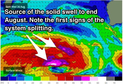
Models are still on track for a solid swell to fill in across the South West around Monday 31st/Tuesday 1st. A particularly strong frontal progression will move across the Heard Island region with a broad fetch and fetches of 55kt gusts.
At this stage, models show this system to split, dividing the swell generating fetch and resulting in a smaller swell, but we should still see 8-10ft surf for the end of August and/or start of September. We are eagerly awaiting the coming models runs to see how it develops.
You are not going to want to hear this, but the outlook for winds doesn't look over good. However, it's still a long way away with plenty of time for the models to clean up their act.

