Slow period until next weekend
Western Australia Surf Forecast by Craig Brokensha (issued Wednesday 6th May)
Best Days: Every morning around Margs besides Saturday
Recap
Average conditions with an easing large swell in the South West yesterday while Perth was clean and fun in the 2ft range. Today a lighter more variable breeze has created cleaner conditions around Margs with a smaller 3-4ft+ of swell while Perth is easing from 1-2ft.
This week (May 7 - 8)
Tomorrow is the best day to surf into the end of the week, with exposed spots in the South West expected to continue around an inconsistent 3-4ft+. Conditions should be clean with an offshore E'ly wind ahead of weak afternoon sea breezes. Perth will be clean but tiny, and Gero fun.
Friday looks to be a touch smaller and with dicier and more variable breezes around Margs, giving into a SW change through the day.
 This weekend onwards (May 9 onwards)
There's nothing major on the cards for the weekend with small inconsistent levels of SW groundswell to 3ft to sometimes 4ft across the South West and 0.5-1ft in Perth. Winds look to be best Sunday with an E'ly offshore around Margs, while Saturday will see a less favourable S/SE'ly.
A couple of slightly better SW groundswell pulses are due Monday and Tuesday across the state from some unfavourably aligned but strong frontal activity to our south-west during the weekend.
A slight increase to 3-4ft+ is due Monday around Margs with morning offshores ahead of a stronger kick to 4-5ft Tuesday under less favourable SE winds.
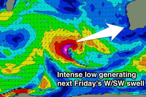
The next considerable increase in swell is due Friday from a strong but fetch-limited mid-latitude low firing up in the central Indian Ocean early next week.
The core winds around the low will reach the storm-force range, but the limited fetch length will limit the size from this low.
We're probably looking at Margs coming in 6ft+ with the W/SW direction and Perth to 2ft to nearly 3ft but winds are looking poor and from the N-NW.
Longer term a very strong node of the Long Wave Trough is forecast to move through the Indian Ocean from early next week, sending a flurry of vigorous cold fronts up towards us. This should produce plenty of size into next weekend and beyond but with what looks to be poor winds.

