Good Friday morning, better Monday next week
Western Australia Surf Forecast by Craig Brokensha (issued Wednesday 18th February)
Best Days: Friday morning, Saturday morning, Monday morning, Tuesday
Recap
Yesterday started small and clean across most locations, while a strong new swell showed late across the South West but sea breezes created average conditions.
The swell held well into this morning, easing from 3-5ft with the odd bigger bomb under early favourable light SE winds, while Perth saw clean 1-2ft sets and Gero bigger 3-4ft waves. The swell has since dropped a touch as onshore winds kicked in.
 This week and early next week (Feb 19 - 23)
The swell should continue to ease into tomorrow morning, but a strong increase in new larger SW groundswell is due through the afternoon across the South West, arriving later in the day around Perth and overnight up at Gero.
This swell was generated by a strong polar low and should build to 5-6ft+ late in the day in the South West, 2ft+ in Perth while Gero should see 3-5ft sets Friday morning. A drop in size is then expected through Friday across Margs from 4-5ft+ and 2ft up at Perth.
Winds will be best around Perth Friday morning with an E/SE'ly while Margs will see SE winds and Gero S/SE breezes.
Saturday should see the swell steady off and winds should swing from SE to E/SE around Perth and Margs as S/SE-SE winds persist up at Gero.
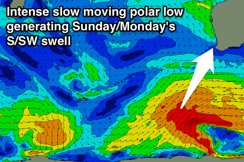
Our groundswell pulses due from Sunday are still on track but the first SW pulse now looks to be more S/SW in direction, followed up by a secondary S/SW pulse for Monday.
This will be related to a strengthening node (peak) of the Long Wave Trough moving towards the Bight and stalling, in turn setting in motion a broad and slow moving polar low to our south-west that is expected to stall to our south-southwest, aiming a fetch of gale to severe-gale SW winds through our swell window.
An initial strong S/SW groundswell is due to fill in Sunday, peaking through the afternoon/evening in the South West to 6ft+ with Perth pulsing late to 2ft and Gero 3-4ft.
Monday morning should see similar sized sets across all coasts ahead of a slight drop in size through the afternoon and more pronounced Tuesday and Wednesday.
Now, winds as pointed out last update should swing from an unfavourable S/SW'ly around to the S/SE later Sunday and then offshore from the E/SE Monday morning. Tuesday should then see E/NE breezes with a S/SE change through Wednesday.
Longer term there's a couple of moderate S/SW groundswell pulses on the cards for the end of the week with favourable winds but more on this Friday.

