Less than perfect outlook, best Saturday morning
Western Australia Surf Forecast by Craig Brokensha (issued Wednesday 17th September)
Best Days: Margs and Perth tomorrow morning, keen surfers Friday morning, Saturday morning, Monday in protected spots
Recap
Another pumping day of waves across Perth and Margs yesterday with a strong but easing SW groundswell under all day offshores in the South West, while Perth saw afternoon sea breezes kick in.
Today the morning was good again but smaller with Gero also offering fun waves. Strong S/SW winds have since kicked in creating poor conditions across most locations.
This week through Monday (Sep 18 - 22)
The surf is expected to bottom out through tomorrow with less than ideal but workable winds from the SE across Margs and Perth with less favourable S/SE winds up at Gero.
A new SW groundswell should fill in Friday and hold well Saturday morning to an inconsistent 5-6ft+ in the South West, 2ft+ in Perth and 3-5ft up at Gero but lingering onshore tending variable winds after a weak change early in the morning will probably create less than ideal conditions across Margs and Perth.
Saturday will be the day to surf with winds quickly shifting around to the E/NE early before freshening from the NE through the morning and tending more N'ly into the afternoon. So surf early for the biggest and best conditions.
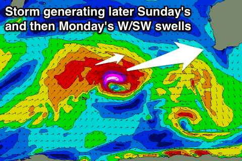
 Sunday will be poor with pre-frontal onshore N/NW winds ahead of a W'ly change through the day. This is unfortunate because a new large W/SW groundswell will fill in through the afternoon generated by a vigorous frontal progression currently pushing east above the Heard Island region.
A tight fetch of severe-gale to storm-force W/SW winds will be projected towards us followed by a broader fetch of SW gales pushing north-east through the Indian Ocean.
This will produce an initial long-period W/SW groundswell for Sunday afternoon to 8-10ft late in the day in the South West, 3ft in Perth and 4-6ft up at Gero.
This swell should ease back Monday but steady as the secondary W/SW swell fills in off the trailing fetch of SW gales. This should keep 6-8ft sets hitting the South West, 2-3ft waves in Perth and 4-5ft surf up at Gero as winds improve but remain average from the S/SE with strength, favouring protected spots.
Next Tuesday onwards (Sep 23 onwards)
The swell should continue to drop away through Tuesday and unfortunately winds look to persist from the S/SE (more SE across Perth).
Winds will go funky as the swell bottoms out Wednesday and unfortunately pre-frontal NW winds are due into the end of the week as some new large swell fills in.
We'll look at this in more detail on Friday though.

