Fun end to the week, large and stormy early next week
Western Australia Surf Forecast by Craig Brokensha (issued Wednesday 3rd September)
Best Days: Thursday, Friday morning
Recap
Good waves were seen across all coasts yesterday morning with a fun swell and offshore winds, while today less favourable winds from the south-east corner created OK surf across most breaks. A new swell has since built as winds remain favourable across the South West and Gero.
This week and weekend (Sep 4 – Sep 7)
This afternoon's kick in SW groundswell should ease through tomorrow under favourable E'ly tending variable winds. The South West should drop from 3-5ft in the South West, 1-2ft in Perth and 3-4ft around Gero.
Friday morning will be great at exposed spots with E/NE tending N'ly winds.
The weekend will be poor with strengthening N/NW winds ahead of a strong frontal system Saturday, while Sunday will see lighter onshore winds and a new pulse of W/SW groundswell and second front moving in through the afternoon.
There'll be nowhere to surf though with the onshore winds from the W/NW.
Next week onwards (Sep 8 onwards)
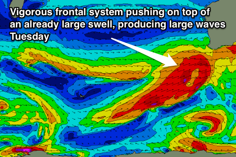
Large stormy waves are still on the cards for early next week as a strong node of the Long Wave Trough moves in from the west and passes across us early next week.
This will bring with it a series of vigorous polar frontal systems, the first firing up west of the Heard Island region tomorrow and projecting north towards us through the weekend, generating an initial large swell for later Monday, peaking Tuesday.
This swell will be overridden by a larger pulse through the day though as a secondary front quickly fires up on top of the swell, projecting an additional fetch of gale to severe-gale SW winds up and into us.
 This should push the swell into the 12-15ft+ range through the day Tuesday in the South West, with stormy 4-5ft waves in Perth and 8-10ft+ surf up at Gero into the afternoon.
The only problem will be the associated winds and they look to be strong to gale-force from the west Monday and then strong but easing from the W/SW Tuesday. Wednesday will likely see lingering fresh onshore W/SW tending S/SW winds around Margs as the swell eases and SW winds in Perth. Gero should see more favourable S'ly winds favouring protected breaks.
Longer term another large and powerful SW groundswell (possibly oversized) is on the cards for Thursday but this one being a long period beast from a very deep and powerful polar storm. We'll keep a close eye on this over the coming days though and provide an update Friday.

