Average weekend, better next week
Western Australia Surf Forecast by Craig Brokensha (issued Friday 29th August)
Best Days: Sunday morning around Perth for keen surfers, Monday, Tuesday morning, Wednesday, Thursday morning
Recap
Gero and Perth offered clean conditions and fun waves with a moderate sized swell yesterday morning before onshroes moved in. These onshores have strengthened into today with a new large W/SW groundswell although Perth and Gero saw small windows of lighter winds early.
This weekend and next week (Aug 30 – Sep 5)
A cold front that's currently pushing in towards the state will pass us during tomorrow morning with fresh but easing SW winds left in its wake across the South West and Perth while Gero will likely still see early NW winds ahead of the southerly shift.
A secondary system will unfortunately clip the state on Saturday night leaving lingering SW winds into Sunday around Margs as the swell continues to slowly ease, but Perth and Gero should see morning SE winds, creating cleaner but likely lumpy conditions.
Monday looks like the day to surf with smaller waves to 3-5ft in the South West, 1-2ft in Perth and 3-4ft up at Gero with offshore E/NE tending variable winds.
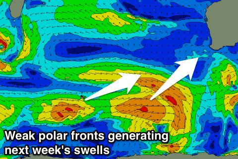
 Through the rest of next week a couple of small to moderate and inconsistent SW groundswells are due from a couple of relatively weak and short-lived cold fronts firing up east of Heard Island.
The first due on Tuesday afternoon and Wednesday morning will be more SW in direction and come in at an inconsistent 3-5ft across the South West, 1-2ft in Perth and 3ft+ up at Gero when it peaks Wednesday morning.
A secondary pulse for Thursday will have a touch more west in it and come in at a similar size besides Gero which should see a touch more size to 3-4ft. Winds look to remain favourable and offshore Wednesday and Thursday, with Tuesday being a little dicey as a weak trough moves through (but early light favourable winds are still due).
Next weekend onwards (Sep 6 onwards)
We should see some better frontal activity developing later next week and into the following weekend as a new node of the Long Wave Trough moves in from the west Thursday and Friday.
Unfortunately winds initially with the building swells will be poor and onshore, but we should see offshores developing from the middle of the following week, but we'll review this Monday. Have a great weekend!

