Large stormy swell for the South West, with cleaner conditions to the north
Western Australia Surf Forecast by Craig Brokensha (issued Wednesday 7th of May)
Best Days: Saturday and Sunday in Perth and Gero, Monday and Tuesday up at Gero
Recap
Yesterday saw fun clean waves across the South West and Gero, while Perth and Mandurah remained tiny. Today an approaching front has moved in bringing strengthening onshores and poor conditions to all coasts, although Perth and Gero saw early favourable N/NE winds.
This coming period (May 9 onwards)
There's been no real change to the large and stormy W'ly swell due across the coast tomorrow and Friday. This swell will be generated by a vigorous mid-latitude front that's just to our west, with the front due to slip south-east while pushing across us tomorrow, slamming a fetch of W/SW gales into the coast.
Margaret River should build to a stormy 10ft+ with 3-5ft waves in Perth and 6-8ft surf around Gero later tomorrow with strong but easing W'ly tending W/SW winds. The swell will drop rapidly once the front moves across us, dropping through Friday with moderate to fresh but easing W/SW winds (lighter around Gero).
Come Saturday the swell will bottom out but winds will remain onshore in the South West, with more variable winds from about Perth north.
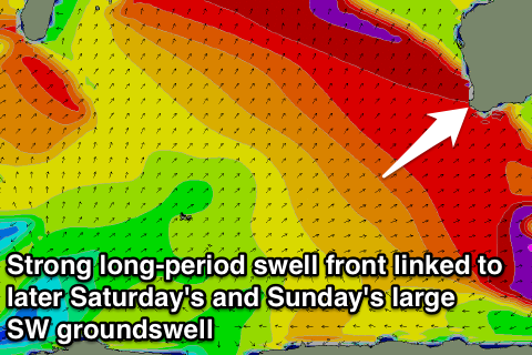
Later Saturday afternoon the first pulse of two powerful SW groundswell pulses is due.
These two swells are being generated by a vigorous polar frontal progression in the Southern Indian Ocean.
Yesterday and this morning, an initial polar low generated a fetch of 35-50kt winds, setting in motion a large and active sea state as well as an initial small long-period swell for Saturday afternoon.
A secondary vigorous polar low will quickly race in over the top of the active sea state in the Southern Indian Ocean, generating an additional fetch of 35-45kt+ W/SW winds while projecting towards WA.
 This should generate a larger SW groundswell pulse for Sunday peaking through the morning to 10-12ft in the South West with larger waves at offshore bommies and reefs while Perth should build to 3-4ft and Gero to 6-8ft through the day.
Winds will remain poor in the South West though as the frontal system generating the swell nears our coast in a much weaker form bringing fresh NW winds that will persist into Monday as the swell backs off a touch.
Perth and Geraldton should be better with more variable winds Sunday morning while Monday is looking a little less favourable.
Longer term we're due for another large SW groundswell pulse Tuesday afternoon and Wednesday but not quite to the size of Sunday's. This is due to the Long Wave Trough stalling off our south-west continuing to aim front after front towards us along with the onshore winds. Check back here on Friday though for any windows of cleaner conditions.

