Fun surf to end the week
Victorian Forecast by Craig Brokensha (issued Wednesday December 4th)
Best Days: Tomorrow, Friday morning exposed beaches, Monday morning Surf Coast, early Tuesday Surf Coast
Features of the Forecast (tl;dr)
- Small-moderate sized, reinforcing mid-period W/SW swell tomorrow AM, easing into the PM and smaller Fri
- E/NE tending N winds tomorrow, back to the E/NE ahead of late sea breezes
- Moderate N/NE winds Fri AM, shifting S/SW into the PM
- Tiny Sat with W/NW tending fresh SW winds
- Good, mid-period W/SW swell Sat PM and Sun AM with strong W/SW tending SW winds (possibly W/NW early)
- Reinforcing local swell Mon with W/NW tending S/SW winds
- Easing swell Tue with early W/NW tending fresh S/SW winds
- Mid-period SW swell Wed with fresh S/SW winds
Recap
Monday’s swell backed off quite rapidly into yesterday morning with early clean conditions to the east that became more wind affected as the day progressed.
This morning the swell is small and mixed with early onshore winds to the east now tending variable, while on the Surf Coast variable offshore winds are creating OK conditions.
A new, inconsistent W/SW groundswell looks to be on the way but it might be on the lower end of the expected scale with South Australia not showing as much size as anticipated.
We should see the Surf Coast reaching 2-3ft this afternoon with 4-5ft sets to the east as winds freshen from the S/SE early-mid afternoon.
This week and next (Dec 5 - 13)
Today’s W/SW energy will be followed up by a secondary pulse of lesser period W/SW energy tomorrow morning and this will hopefully maintain 2-3ft sets on the Surf Coast with 4-5ft sets to the east, easing into the afternoon and then smaller Friday.
Local winds look to shift from the E/NE to N’th through the morning (N/NW to the west and N/NE to the east) before going variable E/NE after lunch ahead of late sea breezes. This should provide plenty of time for a couple of surfs with Friday also coming in clean with a moderate N/NE offshore ahead of a shallow afternoon S/SW change.
Saturday morning looks to be a low point in energy under a W/NW offshore, while freshening SW winds are due into the afternoon as a frontal system moves through. This will also be along with a good pulse of new mid-period W/SW swell discussed below.
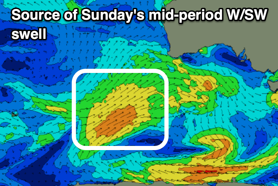
Saturday's frontal system should also bring with it a small, building mid-period W/SW swell on Sunday, but as touched on above, a stronger mid-period W/SW swell will be in the mix thanks to a fetch of strong W/SW winds being generated south-west and south of Western Australia today and tomorrow.

Size wise, Sunday’s swell looks to come in at 3ft on the Surf Coast, easing into the afternoon, 4-6ft to the east with Monday offering weaker 2-3ft sets on the Surf Coast, 4-5ft+ to the east.
Local winds will be generally poor Sunday, strengthening from the W/SW to SW (possibly W/NW early Surf Coast), while Monday looks the pick with a morning W/NW breeze, shifting S/SW through the day.
Into the rest of next week, persistent frontal activity to our south-west early week should generate some reinforcing mid-period swell for Wednesday, while a strong low in the southern Indian Ocean looks to produce a long-range W/SW groundswell for Thursday/Friday. It looks like a local trough/low will bring some overpowering, additional windswell to the mix along with poor winds, but more on this Friday.


Comments
Update, I got the timing and swell source for Monday wrong, that swell is due Saturday afternoon and Sunday morning and has been amended above.
I will wait for the update on Friday regarding surfing conditions on Monday.
Hi Craig, sorry to bother you.
I can't see the Torquay surf report? Getting redirected to hieroglyphics. Tried logging out. Have I been hacked?
Looking into it at the moment mate, for now please use the App.
Thanks Ben, it's been like that for a week or two. Yes app works fine, no dramas
Ha, ha I am looking right up the clacker of a magpie on the portsea cam.