Tricky but favourable outlook for both regions
Victorian Forecast by Craig Brokensha (issued Friday November 29th)
Best Days: Selected spots to the east tomorrow, Sunday, Monday, Tuesday morning, Wednesday morning Surf Coast, Thursday morning
Features of the Forecast (tl;dr)
- Easing mix of SE windswell and SW groundswell tomorrow with gusty E/SE winds (winds lighter E across the PM in the AM and late)
- Smaller Sun with an inconsistent SW swell in the mix under freshening N-N/NW tending stronger W/NW-NW winds
- Inconsistent W/SW groundswell building Mon, peaking in the PM with N-N/NW tending N/NE-NE winds
- Easing swell Tue with fresh N/NE tending NW winds ahead of a late SW change
- Moderate sized, inconsistent W/SW groundswell building Wed, holding Thu AM
- W/NW tending fresh SE winds Wed, variable E-SE tending SE Thu
Recap
Light winds provided decent conditions most of yesterday morning across selected spots with a fun bit of leftover swell energy, while the size increased into the afternoon as winds also started to pick up.
Today we’ve got a moderate sized mix of localised SE windswell and strong new SW groundswell with easy 6ft waves to the east, 3-5ft to the west.

Chunky, windy surf today as the groundswell kicks in
This weekend and next week (Nov 30 - Dec 6)
The mix of SE windswell and SW groundswell seen today will start to ease into tomorrow as winds abate a little throughout Bass Strait.
We’re still looking at average, gusty E/SE breezes, though locations on the Mornington Peninsula look to see lighter E winds at times in the morning, and on dark winds should tend more variable E/NE.
The Surf Coast and Phillip Island regions don’t look to be as lucky.
Easing 3-4ft waves are due on the Surf Coast with 5-6ft waves to the east, smaller into the afternoon and then smaller again Sunday down from 2ft+ on the Surf Coast and 4ft to the east, mixed in with some background SW swell energy.
Winds will strengthen from the N-N/NW during the morning so if to the east, go early, while stronger afternoon W/NW-NW winds will favour the Surf Coast.
Monday looks slow but with some new W/SW groundswell energy expected to fill in through the day. As touched on during the week, the source was a distant storm following the low linked to today’s swell and we’re only expecting very slow 2-3ft sets on the Surf Coast into the afternoon with 4-5ft waves to the east.
A N-N/NW tending N/NE-NE breeze will favour the exposed beaches from mid-late morning onwards, while Tuesday morning also looks good under a fresh N/NE tending NW wind (ahead of a strong evening SW change) as the swell eases.

Looking at Wednesday/Thursday and our good W/SW groundswell is on track but the wind outlook is still a bit up in the air.
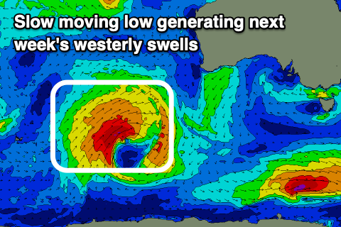
The low linked to the swell will be a slow moving one, with it firing up to the South West of Western Australia today, spawning off a strong frontal system.
Over the coming days we’re set to see fetches of W/SW gales projected through our western swell window, with the low stalling tomorrow before pushing north-east towards WA while weakening into Sunday/Monday.
This will produce various pulses of inconsistent westerly swell, building later Tuesday but most likely peaking Wednesday afternoon/evening and into Thursday morning.
The Surf Coast should reach 3-4ft with 6ft surf to the east and a morning W/NW breeze on Wednesday looks to go SE through the day, with variable winds likely on Thursday but out of the south-eastern quadrant ahead of sea breezes.
We’ll confirm this on Monday. Have a great weekend!

