Surf now or try next week
Victorian Forecast by Craig Brokensha (issued Friday October 20th)
Best Days: This morning, exposed beaches to the east Monday morning and Tuesday
Features of the Forecast (tl;dr)
- Strong SW winds tomorrow with a localised SW windswell, easing Sun with fresh S/SW winds
- Small, inconsistent W/SW swell Mon AM, ahead of a better increase later in the day, easing Tue
- Strong E tending E/SE winds Mon, local offshore out of the N Tue ahead of a late S/SW change
- Lingering S/SW winds Wed and small
- Moderate + sized swell for late week with likely strong SW-S/SW winds
Recap
Pumping surf across the beaches yesterday and even into this morning as the tide comes up. We saw a long-range W/SW groundswell coming in just under the size to make it annoying with tricky closeout sets, but also just over the size to make it accessible for the intermediate to experienced.
The Surf Coast built to 2ft yesterday with 5ft sets to the east, remaining clean all day and good with the middle of the day high tide.
This morning the Surf Coast is still 2ft with 4-5ft sets to the east and conditions are favourable for the beaches but will deteriorate into the afternoon as a weak low moves across us.

Clean and sizey sets this morning
This weekend and next week (Oct 21 - 25)
Today’s weak low will bring with it a strong SW change late afternoon and with this some localised windswell for tomorrow but to no major size or strength, as is the flukey nature of the low.
Conditions will be poor in any case with a strong SW breeze persisting tomorrow, remaining fresh from the S/SW on Sunday along with easing levels of size.
So with this in mind make the most of the current window of light winds.
Monday should see winds swing around to the E but with strength as the low moves into the Tasman Sea, squeezed by high pressure moving in from the west.
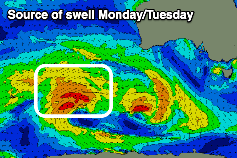
Swell wise, nothing major is due until later into the afternoon and more so Tuesday, when a long-range, mid-period W/SW swell arrives.
Before this the Surf Coast looks to be 1-2ft, mixed in with some SE windswell with slow 2-3ft sets to the east.

The better swell for later in the day and Tuesday has been generated by a good, persistent but distant fetch of strong to sub-gale-force W/SW winds to the south-west of Western Australia.
With this, the Surf Coast looks to come mostly in at 2-3ft with 4-5ft sets to the east later Monday and early Tuesday (easing through the day). Tuesday morning looks like the pick with a moderate N/NE wind to the east and N-N/NW winds to the west, shifting S/SW later as a trough moves through.
This trough looks to be attached to a broader, deepening low which should bring some moderate sized + swell into the end of next week, but the models diverge a little regarding the strength and local winds. They do look both generally poor and onshore at the peak of the swell, but more on this Monday. Have a great weekend!

