It's the beaches time to shine
Victorian Forecast by Craig Brokensha (issued Monday October 14th)
Best Days: Tomorrow to the east, Wednesday and Thursday to the east, Friday morning to the east
Features of the Forecast (tl;dr)
- Moderate + sized S/SW groundswell for tomorrow AM, easing into the PM, then fading Wed
- Moderate sized SE windswell also in the mix tomorrow, easing Wed
- Strong E winds tomorrow, tending E/NE at times to the east
- Mod-fresh E/NE-NE winds Wed, tending SE into the PM to the west
- Inconsistent, long-period W/SW groundswell showing later Wed, peaking Thu, easing slowly Fri
- Fresh NE tending E/SE winds Thu, strong N/NE tending NW Fri
- Early W/NW tending stronger W/SW-SW winds Sat with a moderate sized increase in SW windswell
- Easing windswell Sun with W/SW-SW winds
Recap
A mix of sizey swells pushed into the Surf Coast on Saturday with 5ft+ sets across the exposed reefs and more size to the east. Conditions were bumpy and not ideal but doable for the keen and experienced with some firing options to the east.
Yesterday the swell was on the decline and conditions cleaner with a N’ly breeze. The Surf Coast backed off from the 3-4ft range with solid sets easing from 6ft to the east.
This morning a trough has brought average conditions with smaller surf (fun still to the east).
This week and weekend (Oct 14 - 20)
The coming week revolves around mostly the next few days and strong winds due as the trough moving through today deepens into a low off the East Coast.
The interaction between a high to our south-east and the low to the north will see strong E/SE winds develop this evening, holding from the E tomorrow (E/NE at times to the east), kicking up some sizey localised windswell on the Surf Coast.
It’ll add peaks to the mix on the Mornington Peninsula and Phillip Island along with our new S/SW groundswell.

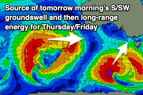
The size of this groundswell has been upgraded, with the low linked to it coming in a little stronger and forming earlier than forecast on Friday. A great fetch of severe-gale SW-S/SW winds were generated through our southern swell window and this should produce a moderate + sized groundswell to 4-5ft+ on the Surf Coast early tomorrow with 6ft+ sets to the east (not ideal), easing through the day. With this easing trend in mind and winds remaining relatively favourable the afternoon might be best to the east.
Wednesday will see the SE windswell and S/SW energy fading rapidly, with easing 2ft to occasionally 3ft sets at dawn on the Surf Coast, with similar 2-3ft waves to the east.
Into the afternoon, the forerunners of a long-period and distant W/SW groundswell are likely to be seen, but Thursday should reveal the peak in size. Coming back to the local winds on Wednesday, an E/NE-NE breeze is due most of the day to the east of Melbourne, shifting SE into the afternoon on the Surf Coast.
Thursday will then see NE winds in the morning, shifting E/SE into the afternoon with the distant groundswell coming in at 2-3ft+ on the Surf Coast and 4-5ft+ to the east (but inconsistent).
The swell will fade through Friday and early, strong N/NE winds will favour the exposed beaches to the east ahead of a NW change into the afternoon.
This change will be linked to a deepening mid-latitude low developing directly west of us and then moving east on the weekend bringing with it W/NW tending strong W/SW-SW winds on Saturday and some weak, localised windswell.
Longer term there’s nothing too major on the cards with us relying on long-range W/SW swell energy but with favourable winds for the beaches. More on this Wednesday.

