Lots of swell to come with winds from all directions
Victorian Forecast by Craig Brokensha (issued Friday October 11th)
Best Days: This morning Surf Coast, tomorrow morning selected locations, Sunday, selected locations east of Melbourne Tuesday and Wednesday morning
Features of the Forecast (tl;dr)
- Moderate + sized mix of groundswells Sat with moderate S/SE winds (light for a period during the AM), freshening into the PM
- Easing surf Sun with mod-fresh N/NE winds to the east, N/NW to the west, tending N, then NW later ahead of an evening SW change
- Smaller Mon with SW tending strong S then SE winds
- Localised SE windswell Tuesday along with a moderate sized S/SW groundswell with strong E-E/NE winds, E/SE later
- Easing mix of SE and S/SW swells Wed with strong NE winds, tending W then strong SW into the PM
- Long-range W/SW groundswell Thu with S winds
Recap
The surf was small to tiny yesterday with a dawn window of OK conditions east of Melbourne before quickly deteriorating.
Today we’ve got a close-range W/SW well mixed with some long-range W/SW groundswell on the build. The Surf Coast is a clean 3ft with larger, wind affected 5ft waves to the east and we’ll see the size building further this afternoon but with a strengthening SW’ly from midday.
This weekend and next week (Oct 12 - 18)
Today’s mix of swells were generated by a strong frontal progression that moved through the southern Indian Ocean earlier this week. A stronger, more consistent W/SW groundswell due into tomorrow was then generated by the same progression as it moved under Western Australia mid-week, with a trailing fetch of W/SW winds continuing to be generated in our south-western swell window last night and this morning.
This should all amount to waves in the 5ft range on the Surf Coast tomorrow with 6ft to occasionally 8ft sets to the east but with moderate S/SE winds lingering in the wake of this afternoon’s change. There’ll likely be a period where winds become lighter during the morning before freshening again into the afternoon.
Sunday is still the pick of the weekend with winds due to swing back to the N/NE (tending N/NW in pockets on the Surf Coast) along with easing 3-4ft surf to the west and 6ft waves to the east. Winds will actually freshen and hold from the N-N/NE to the east into the afternoon and tend more N/NW-NW later to the west so this should offer a full day of great surf.
On dark, a SW change is due, thanks to a trough moving in from the west, with early light SW tending stronger S-S/SE winds due on Monday as it moves through Bass Strait. If there’s any stalling of this system the Surf Coast will likely be clean early, but there’ll be no size left in the tank.

Later in the day winds will become quite strong from the E/SE as the trough deepens into a low east of us, and this will see strong E’ly winds persisting into Tuesday, tending E/NE across the Mornington Peninsula and Phillip Island regions through the morning.
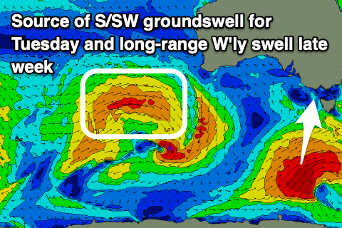
Swell wise, the Surf Coast will see a stormy windswell kicking to the 4ft range on Tuesday, while a background S/SW groundswell should be seen across locations east of Melbourne. The source will be a strong polar low forming south-west of Tasmania on Sunday and this should produce surf to 4-5ft+ to the east. The combo of swells should make for some interesting surf.
Come Wednesday, both the windswell and S/SW groundswell will be easing and strong NE winds will favour the exposed beaches during the morning, shifting W and then SW into the afternoon as another trough moves across the state.
This will unfortunately see lingering S winds on Thursday, spoiling a long-range W/SW groundswell next Thursday. Longer term we’re looking at a poor run of SE-S winds so make the most of the coming windows of clean surf. Have a great weekend!


Comments
was very speccy at the SC swell magnets this morning with a clearly visible aurora that went till 6am. got some good shots before hitting the water, if only i could figure out how to load pics here
Imagebb is the easiest way I’ve found
I tried using that on the comments page where it talks about uploading images, couldn't get it working
here's a link at least
https://ibb.co/S5TrYx2
https://ibb.co/y0pP7V9
https://ibb.co/ws7KgDZ
Awesome.

You got it.
Edit: GF beat me to it. You can just copy the "Full image" code as well, means the image doesn't disappear when you or they delete the original.
Liked the first one too.
Where it asks you to choose the Embed Codes you need to choose Full Linked.
You’re so close!
[img] [/img]
[img]
duplicate email finder
[/img]
What do you think about winds holding from then nne / ne phillip island kilcunda zone Sunday? Saying on some models it’s going nnw through out the morning. Thanks Craig
Wow, incredible!
Fantastic pics there PLStocks!
Depending on who you view, this is Kp 9, or Kp 8.5 which is higher than that huge solar storm around May
https://www.sws.bom.gov.au/Aurora/1/1
https://www.swpc.noaa.gov/products/planetary-k-index
really powerful!
wow didn't know that info existed and didn't know it was coming. pays to be a dawn patroller now and then
Hope there's still a bit left after work when dusk arrives
The obvious spots out of the southerly were pretty pumping this morning - looked like PIBC absolutely cracked it for their teams comp which made the other spots extra busy.
Water feels like it’s finally turned a corner!
That shallow evening change held true..