Great surf developing late week on the beaches
Victorian Forecast by Craig Brokensha (issued Monday September 30th)
Best Days: Later tomorrow morning Surf Coast ahead of the change, Thursday, early Friday exposed beaches
Features of the Forecast (tl;dr)
- Moderate sized mid-period W/SW tending SW swell building tomorrow, peaking Wed, easing steadily Thu
- W/NW tending variable winds tomorrow AM ahead of a S/SW change early PM
- Light-mod E/SE-SE tending fresher SE winds Wed
- Freshening N/NE-NE winds Thu
- Stronger N/NE-N winds Fri with a fading swell
- Small mid-period W/SW swell building Sun with W/NW winds
- Small-mod sized W/SW swell Mon with W/NW tending SW winds
Recap
Great surf across the exposed beaches for Grand Final day with offshore winds and fun sized sets to 3-4ft, smaller on the Surf Coast.
Yesterday still provided clean conditions but much smaller surf to the east, tiny to the west.
Today a small W/SW swell has provided a small lift in energy to the 2ft range on the Surf Coast, a little bigger to the east but wind affected.

Saturday morning lineup
This week and weekend (Oct 1 - 6)
The week ahead will generally favour the exposed beaches to the east, with an incoming frontal progression due to produce a moderate sized pulse of mid-period swell Wednesday before clearing quickly to the east, allowing high pressure to move in.
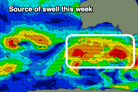
We’re seeing multiple fetches of strong to at times gale-force winds generated through our western and south-western swell windows, with building levels of mid-period energy due tomorrow morning, more so into the afternoon ahead of a peak through Wednesday. The initial energy will be west in nature, swinging more south-west through Wednesday owing to the frontal progressions movement through our swell windows.

Conditions ahead of the swell generating system look clean tomorrow morning on the Surf Coast with a W/NW offshore, and size wise, we should see building levels of mid-period W/SW swell that will likely reach 3ft (smaller early) on the Surf Coast before winds shift S/SW midday/early afternoon and strengthen into the evening.
Wednesday should see winds back off but still be light-moderate from the E/SE-SE in the morning, freshening through the day along with the peak in swell to 4ft+ or so on the Surf Coast, 6ft+ to the east.
Thursday and Friday morning will be much better for a surf with a steady drop in size along with freshening N/NE-NE offshore on the former, stronger N/NE-N on the latter.
The Surf Coast looks to ease back from 3ft+ on Thursday morning with 4-5ft+ sets to the east, becoming more manageable into the afternoon and then down from 1-2ft and 2ft to occasionally 3ft respectively west and east of Melbourne Friday.
Moving into the weekend, the surf will remain tiny on Saturday with a shift in wind to the west, while some new mid-period W/SW swell is due to build slowly Sunday, generated by a mid-latitude frontal system passing under Western Australia Friday afternoon/evening.
No major size is expected with small 2ft+ waves due to develop across the Surf Coast under a gusty W/NW breeze, while Monday looks to see a little more size to 2-3ft as winds favour locations west of Melbourne through the morning.
Longer term there’s nothing standout on the cards so make the most of Thursday, with it looking to be the pick of the bunch.

