Poor weekend, with another good run of swell and offshores from later next week

Victorian Forecast by Craig Brokensha (issued Friday September 13th)
Best Days: Tuesday Surf Coast, Thursday onwards Surf Coast
Features of the Forecast (tl;dr)
- Moderate + sized SW groundswell for later today and tomorrow morning, easing slowly Sunday and Monday
- Fresh to strong S/SW-SW winds tomorrow, fresh to strong S/SE tending weaker S/SW Sun
- Strong SW winds Mon
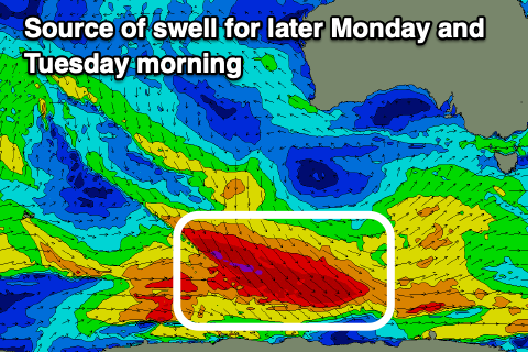
- Moderate sized mix of S/SW groundswell and close-range swell for later Mon, peaking Tue AM, easing
- Fresh W/NW winds Tue
- Moderate sized mid-period SW swell building Wed with strengthening N/NW tending W/NW winds
- Larger surf building Thu, likely peaking Fri with persistent strong W/NW-NW winds
Recap
Terrible conditions across all locations yesterday with a drop in W/SW swell energy from Wednesday along with gusty onshore winds.
This morning marks a low point in swell energy with cleaner conditions on the Surf Coast but waves mostly to 2ft. A good new SW groundswell is due to build into this afternoon but with a shift in winds to the SW strengthening later.
This weekend and next week (Sep 14 - 20)
There’s been no change to the wind outlook for the weekend ahead unfortunately, with onshore breezes due to spoil a strong pulse of SW groundswell.
The broad and disjointed low linked to this swell has done all its work, with the swell due to build this afternoon but peak tomorrow morning to 4-5ft on the Surf Coast magnets, 6ft to occasionally 8ft to the east.
We’ll see this evening’s strong SW change will be reinforced by a polar front sliding up the eastern edge of a high into tomorrow, leaving fresh to strong S/SW-SW winds across all locations. There’s a very slim chance of lighter W/SW winds at dawn on the Surf Coast but conditions will be raw and lumpy regardless.
Sunday should see fresh to strong S-S/SE winds, easing through the day and tending more S/SW as the swell eases.
Monday now also looks average with a general strong SW flow as polar fronts continue to skirt around the south-eastern flank of high pressure sitting to our west.
The front bringing this wind will also generate a small increase in closer-range SW swell through the day, while a stronger S/SW groundswell is on the cards for the afternoon and more so Tuesday morning.
This will be generated by a fetch of severe-gale W/NW winds projecting down along the polar shelf today and under us tomorrow but tending more NW and away from us.
The size looks a little limited but we should see 3ft to possibly 4ft sets on the Surf Coast magnets, easing through the day with 5-6ft to the east under a fresh to strong W/NW breeze.

Of greater significance is the start of a great looking Southern Ocean frontal progression firing up under the country mid next week.
The strength and make up of each front is still yet to be settled, but we’re due to see back to back to back fetches of gale to severe-gale W/SW winds firing up towards us, generating moderate to large pulses of W/SW groundswell from Thursday through next weekend and early the following week.
Nailing down the largest pulses is a little tricky but for now they look to be Friday and Sunday to early the following week. We’ll look at this closer Monday. Winds look favourable for the Surf Coast and generally out of the north-western quadrant but check back Monday for a clearer idea. Have a great weekend!
Comments
Dead whale at 13th.
Lucky the surf is shit.
Oh, no good. Plans to move it?
Dunno, I just saw it on social media.
Doesn’t look like an easy job.
https://www.instagram.com/stories/aframephotos/?hl=en
Not looking to be offshore winds there for a while, so won't have to make the decision between sensible/stupid/brave.
Anyone else got a theory for all these NE for the last month on the surfcoast when the wind was forecasted for light north westerlies. Is this a common springtime thing or related to the warming of our winter land temps in regard to the ocean temp turning the katabatic winds towards a more seabreezey angle. This past week hasn't been as noticeable but down the GOR its been quite noticeable. http://www.bom.gov.au/products/IDV60801/IDV60801.94846.shtml
That's an error with the weather station, I've been watching closely and none of them are real. The morning N-N/NE winds that is.
Possibly there's some calibration error but the on the ground daily observations are the same as what it says. If you've ever been down the great ocean rd by foot, bike or car and felt the way certain winds will flow out of some valleys and significant temperature differences from one corner to the next Youd know how some parts of the coast like certain winds and others don't. Whenever the clouds are like this and the weather feels like this weather its very likely for the winds to go just east of north but it just seems more consistent at the moment. If your observations are based off the cams which are either side of the Aireys obs, at select locations you can easily be tricked with some parts of the coast not seeing the same effect. Take the 6th of August for example in the following images you can see the time stamps. Here you can see fairhaven with a moderate NE crumbling the lip which went the whole coast up to about the bells area which was perfectly offshore.


Yeah it's a long stretch of coast and there are varying topographical effects but in general I believe it's been as Weatherman says more NW than NNE.
Have you noticed at the coast it being more east of north in general?
This observation was based off being by the beach every morning further down the road.... it's been surprisingly (not surprising when I wake up, see the clouds and feel the weather) much more consistently NNE when the models think it to have more westerly flow in it. To the untrained eye these next two pictures won't look like much, consider the influence hasn't been as strong this past week, but when the slow-moving clouds are like this with a warm morning breeze and you can see the surface ruffle like this it's likely the winds are tipping east round ere. The cameras also struggle to see further out into the bay and around the corners of these jutting headlands where the effect is more pronounced from the longer fetch.

I've had the feeling the Aireys wind observations haven't been correct at times the last few weeks. It's been saying N or NNE but you go down the beach and it's NW or WNW. I know the wind can be different along the GOR compared to Torquay at times as dbut says.
Warnings in place not to enter the water at 13th and Ocean Grove because of fear of sharks
A heads up to vicco/Tas/NSW sth coast and NZ crew wanting a bit of extra intel on distant swells deep to the south, there's currently 3 University of WA buoys drifting freely with 2 of them still giving live updates. Could come in handy for a little sneaky pulse away from the crowds. https://wawaves.org/