Better late than never!

Victorian Forecast by Craig Brokensha (issued Monday August 26th)
Best Days: Surf Coast from Wednesday through mid-next week (excluding Monday at this stage)
Features of the Forecast (tl;dr)
- Easing W/SW swell tomorrow with strong N/NW-N tending N/NW winds
- New moderate sized W/SW groundswell for Wed AM, with a larger, localised swell building into the PM, peaking Thu AM, easing
- Strong W/NW tending W winds Wed, mod-fresh NW Thu
- Smaller Fri with strong N/NW tending W/NW-W winds
- Large W/SW groundswell building Sat PM, peaking Sun AM
- Oversized W/SW groundswell building late Sun, peaking Mon AM
- Strong W/NW tending NW winds Sat, W/NW-NW Sun
- Strong W/SW-SW winds Mon
Recap
Friday’s, pumping pulse of W/SW swell eased back through the weekend with clean, 2-3ft sets on the Surf Coast Saturday, 1-2ft yesterday. Locations to the east were smaller and wind affected.
Today started tiny but a new pulse of W’ly swell is due into the afternoon, possibly reaching 2-3ft on the Surf Coast as winds persist from the W/NW.
This week and weekend (Aug 27 - Sep 1)
Better late than never!
We’re finally looking at an outlook that’s generally expected through the middle of winter, with all the strong activity that’s been primarily focussed in the Indian Ocean moving east, more towards the south-east of the country.
With this we’re set to see multiple, significant swell generating systems firing up through our swell windows, producing a large, extended run of pumping surf for the Surf Coast.
First, looking at tomorrow and our pulse of flukey W’ly swell for this afternoon was generated by a strong but weakening frontal system dropping east-southeast from under Western Australia on the weekend and through today. This is due to ease back through tomorrow from the 2ft+ range on the Surf Coast, 4ft to the east under strong N-N/NW winds that will shift N/NW into the afternoon.

Later in the day but more so Wednesday, our first pulse of W’ly groundswell is due, produced by another poorly aligned but significant fetch of severe-gale to storm-force W/NW-NW winds passing under Western Australia today.
The swell from this system is due to peak Wednesday morning to 3-4ft on the Surf Coast magnets with 6ft sets to the east, but we’ll see a rapid increase in short-range W’ly swell on top of this through the day as a strengthening frontal system moves through Bass Strait.
A fetch of gale-force W’ly winds stretching from us to Western Australia should kick up a building swell to 6ft on the Surf Coast into the late afternoon, 8ft+ to the east with a peak Thursday morning to 6-8ft and 8-10ft due respectively west and east of Melbourne, easing during the day.

Strong W/NW tending W winds are due on Wednesday with Thursday seeing excellent, moderate to fresh NW winds all day.
Friday will be smaller and half the size of Thursday morning, and strong N/NW winds are due to shift W/NW-W through the day.
This will be ahead of the next swell generating storm, with that being another broad, expansive fetch of W/SW gales setting up under the country, surging towards us during Friday and early Saturday, followed by a secondary, stronger fetch of severe-gale W/SW tending W/NW winds moving in on top of the active sea state Saturday/Sunday.
What we should see from these developments is a large W/SW groundswell building Saturday, back to 6ft on the Surf Coast into the afternoon, 8ft+ to the east, peaking Sunday to 6-8ft west of Melbourne and 10ft to the east.
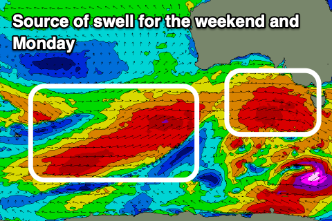
The fetch of severe-gales should generate an even larger pulse for later Sunday but more so Monday morning to 8-10ft and 12ft+ respectively. There’s bound to be some slight shifts to the timing of the swell peaks so check back here Wednesday and Friday for any tweaks.
Local winds will favour protected spots with strong W/NW tending NW winds on Saturday, W/NW-NW all day Sunday and then possibly shifting W/SW-SW through Monday.
Longer term, the activity looks to settle a little into next week but with great conditions continuing for the Surf Coast. See you back here Wednesday.
Comments
Woohoo, nice one Craig
time to crack out the gun
Praise Craigos!
praise be to the king!
Craig is our King. I've heard there's great banks at Jan Juc atm, will this swell hit those well do we think?
Bugger, she’s been a good run over ‘ere
Last Friday was one of the best surfing days of my life. Love that’s there’s a change in seasons to surf something a little but there’s already been some magical days and I feel this run of westerly energy isn’t as special as what some may think IMO.
Er, looks pretty bloody good !?
Last Friday was special. Summer in August was weird. Winter is coming.
Wasn't it?! Felt like the first day we've had like that in months. Very fun waves.
Smallish tides all weekend.... could be a total circus
Late last week I prayed to our Saviour Craig'os aka The 'Os for swell. And he delivers in this manner! can't wait for the fever to strike our shores and may The 'Os put his snout in the trough and feast a thousand times to the sun and back.
Hahaha.
The O’s
Haha that’s amazing.
The models look like a North Shore forecast at the moment.
12-15 foot forecast for Phillip Island tomorrow!
You might see a few sub-tropical birds start flying in for these swells.
Will get my anti this is livin signs ready