Average end to the week, better from the weekend
Victorian Forecast by Craig Brokensha (issued Wednesday May 22nd)
Best Days: Saturday, Sunday across exposed breaks, Monday, Tuesday, Wednesday, Thursday, Friday Surf Coast
Features of the Forecast (tl;dr)
- Easing swell tomorrow with WNW winds to the west, W/SW to the east
- Moderate sized mid-period SW swell building Fri, peaking in the PM but with gusty S/SE winds arriving shortly after dawn, tending lighter S into the PM
- Easing swell Sat with N/NE winds to the east and variable S/SW winds to the west
- Smaller Sun with N'ly tending variable winds
- Inconsistent SW groundswell for Mon with NW tending variable winds (tending N/NE into the PM to the east)
- Small W'ly swell Tue with similar winds to Mon
- Moderate sized W'ly groundswell Wed with local offshore N'ly winds, strengthening from the N/NE into the PM
- Easing swell Thu with N tending W/NW winds
Recap
Yesterday was a lay day across the Surf Coast with a moderate to fresh onshore wind and drop in swell from Monday, with a couple of workable options to the east.
This morning we’ve got cleaner conditions across all regions with a more variable wind and inconsistent new S/SW groundswell that’s to 3ft on the Surf Coast and 4ft on the sets to the east. Winds look to remain favourable for the Surf Coast until around early afternoon and longer to the east as a trough lingers in the region, but finally shifts east into the afternoon. This will be with easing amounts of swell though.
This week and weekend (May 23 - 26)
This morning’s limited kick in size will fade into tomorrow, with smaller though clean options left across the Surf Coast, onshore to the east.
We then look towards our window of possible clean conditions Friday morning with a moderate sized, building mid-period SW swell into the afternoon.

Unfortunately an incoming trough looks to bring a gusty S/SE change by mid-morning (likely earlier), well ahead of any real increase in size, with dawn W/NW winds only likely to greet a small 2ft of swell on the Surf Coast.
The new swell should reach 4ft on the sets into the afternoon on the Surf Coast and 6ft to the east, generated by a healthy polar low moving under the country today and tomorrow.
Saturday looks to provide better options for a surf as the swell eases from 3-4ft and 5ft respectively with N/NE winds to the east of Melbourne and more variable S/SW winds to the west. There’s a chance for early W/NW winds on the Surf Coast but this depends on the location of the trough and we’ll have a clearer idea on this Friday.
Sunday will become smaller but with cleaner conditions across selected breaks with a N-N/NW breeze on the Surf Coast and N’ly winds to the east, tending variable through the afternoon. The surf will be smaller and fading from 2ft on the Surf Coast and 3ft to possibly 4ft to the east.
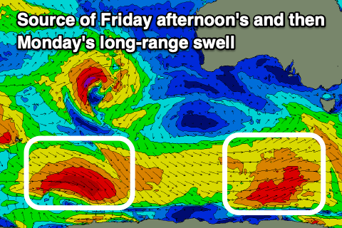
Into the evening but more so Monday, a very inconsistent, long-range SW groundswell is due, generated by a strong but very distant storm that formed south-east of South Africa and is currently around the Heard Island region.
It’ll be very slow, but we should see 2-3ft sets on the Surf Coast magnets Monday morning, 4-5ft to the east and with favourable NW winds continuing, tending N/NE to the east into the afternoon, creating improving conditions as the swell starts easing.
Now, into Tuesday, the first pulse of W’ly swell from an active storm track projecting towards but then breaking down once crossing Western Australia is due.
While being large for Western Australia and Indonesia, the area of generation and distance from the Victorian coast will result in smaller, less consistent swell pulses.
The first swell Tuesday looks small and very west, likely not getting much over 2ft+ on the Surf Coast and 4ft to the east but with similar winds to Monday.

A better pulse of W’ly groundswell should be seen into Wednesday and Thursday though, produced by one of the storms moving through the Indian Ocean maintaining its strength right up until Western Australia.
Fetches of gale to severe-gale W/SW winds should generate a moderate sized W/SW groundswell for Wednesday to 3-4ft on the Surf Coast magnets and 6ft+ to the east but with favourable, local offshore winds, strengthening from the N/NE into the afternoon.
Follow up pulses of W’ly swells are due through the end of the week as the frontal activity briefly penetrates the Bight, bringing a N tending W/NW change Thursday, likely back to the N/NW Friday. Things are bound to change this far out so check back here Friday for the latest.


Comments
Wed. next week looks good for W.P..
:-)