Large, strong groundswell inbound but with average winds

Victorian Surf Forecast by Craig Brokensha (issued Monday 30th October)
Best Days: Today Surf Coast, tomorrow morning Surf Coast, Thursday morning for the keen, possibly Friday
Features of the Forecast (tl;dr)
- Large SW groundswell building tomorrow, peaking in the PM
- Fresh W/NW tending strong W/SW-SW winds late AM and into the PM
- Large, easing swell Wed with fresh SW-S/SW winds (very low chance light W early Surf Coast)
- Easing surf Thu with light-mod S winds, freshening from the S/SW during the day
- Small-mod sized, reinforcing mid-period SW swell later Thu and Fri AM with moderate S/SW-S/SE winds
- Fading surf Sat with fresh S winds
- Building S/SE windswell Sat PM and Sun with strengthening SE winds
- SE windswell Mon with strong E/SE winds
Recap
The surf dropped right back into Saturday but conditions were clean with small 2ft leftovers on the Surf Coast magnets, 2-3ft to the east and best through the morning.
Yesterday was small to tiny with light winds for the desperate.
Into the afternoon a small pulse of mid-period W/SW swell was seen, peaking this morning with clean 2-3ft sets on the Surf Coast, 4ft to the east. Winds are due so shift NW through the morning and then weak W/SW-W briefly through the afternoon as a trough slides through, but winds will then likely strengthen from the W/NW again later.
This week and weekend (Oct 31 – Nov 5)
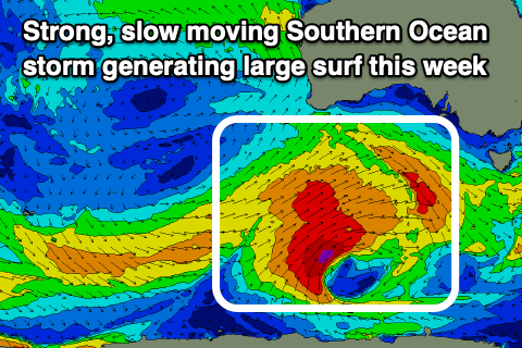
Later this evening's strengthening winds are linked to a strong Southern Ocean frontal progression moving in from the south-west, with it firing up to the south of the country on the weekend.
We've seen this slow moving frontal progression generating a fetch of strong to gale-force winds, with a great slingshot of gale to severe-gale SW winds being projected towards us on top of this active sea state.
A large SW groundswell will be generated for tomorrow, building through the day and peaking during the afternoon. The Surf Coast magnets are on track to reach 6-8ft with 8-10ft sets to the east and morning W/NW winds will create the cleanest conditions before winds shift strong W/SW-SW late morning and into the afternoon.
The swell is due to ease through Wednesday but the Surf Coast magnets should still be seeing 6ft sets on the magnets early, 6-8ft to the east and with lingering, fresh SW tending S/SW winds.
The chance for an early light W'ly on the Surf Coast looks low, and in any case conditions will be lumpy and raw so don't expect much in the wave of quality.
Thursday will see a continuation of easing swell and with lingering S'ly winds, light enough in the morning to create workable conditions for the keen. The Surf Coast looks to be easing back from 3ft and 4-5ft to the east.
Into the afternoon a new pulse of reinforcing mid-period SW swell is due, generated by a broad fetch of strong W/NW winds pushing in behind the current progression and this should maintain 3ft sets to the west on Friday morning, 4-5ft to the east, easing through the day.
A small trough and low lingering east of us will interact with a high in the Bight, bringing persistent S/SW-S/SE winds across both coasts Friday, though there's a chance winds go more variable if the low retrogrades west.
Regardless the low looks to shift back east on Saturday as the high strengthens bringing fresh S'ly winds with smaller surf.
Unfortunately the interaction of this high and the low will dominate the weekend with strengthening S/SE-SE winds due along with building levels of local south-east windswell though with no quality.
Strong E/SE-E winds are due into early next week and the high will block all swell sources.
So all in all make the most of tomorrow morning and maybe an onshore surf over the following days.
Comments
You're going to have to replace your 'S' button soon.
Ha, wouldn't believe it but it's the most worn out on the keyboard. Would be from writing swell and sea breeze so much :p
sunshine is the sweetest in the summer seasons with southerly swell
What you tipping for the early tomorrow Craigos? We expecting much of that solid new groundswell then?
Should be just edging in, so a good size I'd say.
(:
Rubbish winds that won't go away ..... :-(
Waves really muscling up! Yewww