Large onshore swells, but small and weak when clean

Victorian Surf Forecast by Craig Brokensha (issued Friday 20th October)
Best Days: Today ahead of sea breezes, dawn tomorrow exposed locations, early Tuesday and Saturday week swell magnets
Features of the Forecast (tl;dr)
- Small tomorrow with early N winds, tending W/NW mid-morning and strengthening
- Large building S/SW swell Sun PM, easing slowly Mon
- Strong W/NW winds Sun, tending SW late AM
- Strong W/SW winds Mon AM, easing and tending SW (slim chance for early W-W/NW winds Surf Coast)
- Fading small swell Tue fresh N-N/NE winds, ahead of a strong late afternoon W/SW change
- Strong W/NW tending SW winds Wed with a building swell into the PM
- Mod-large S/SW swell Thu with strong but easing S/SW-SW winds
- Easing surf Fri with light-mod S/SE winds
- Small Sat with N/NE winds
Recap
Our good S/SW groundswell came in nicely yesterday with clean conditions and waves to 4ft on the Surf Coast and a large 6ft to the east. Conditions remained favourable for most of the day with weak sea breezes adding some small bumps.
This morning the swell is easing but conditions are great again for all locations with easing 4ft sets to the east, 3ft to the west. Expect sea breezes to develop mid-late afternoon, possibly improving right on dark again.

Glassy bombs yesterday PM
This weekend and next week (Oct 21 - 27)
Make the most of the current surf because as pointed out in the forecasts earlier this week, the coming period from the weekend through next week will consist of troughy, mid-latitude systems moving in from the west, bringing localised swell but poor winds.
Looking at tomorrow and the current swell will fade further and early local offshore winds are due to quickly shift W/NW by mid-morning, strengthening into the afternoon.
The Surf Coast looks to be 2ft with 3ft+ sets to the east.
Into Sunday strong W/NW winds are due to shift SW late morning and hold into the afternoon as a deepening low to our west pushes east.
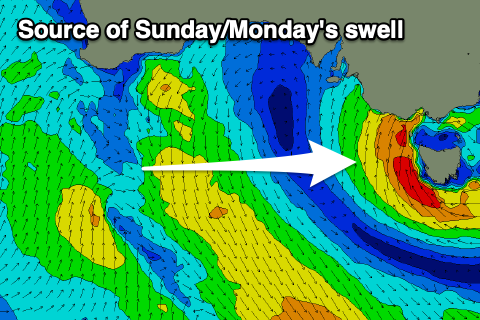
The low will sit west and north of our swell window tomorrow, only becoming more favourable on Sunday as it moves east, directing a slow moving fetch of strong to near gale-force S/SW winds up past Tasmania's West Coast and through Bass Strait.
This will produce a large sized, building S/SW swell through Sunday, really muscling up into the afternoon but with those poor, strong SW winds.
Building surf to the 6ft range is likely on the Surf Coast, larger to the east, then easing on Monday from a similar size but with strong W/SW winds, easing and tending more SW through the day. There's an outside chance for early W-W/NW winds on the Surf Coast but the surf will still be very raw, bumpy and lumpy.
Tuesday should see a rapid improvement in conditions as winds shift to the N/NE-N and freshen along with smaller, weak, easing 2ft sets on the Surf Coast, 3ft to the east.
The next approaching system will be a deepening mid-latitude low with a polar front attached to it's base, producing quite a meridional (south to north) fetch of strong S/SW winds through our swell window.
The trough is due to move through Tuesday evening, bringing a strong W/SW change, though reverting back to the W/NW Wednesday morning before shifting back SW late morning. Swell wise there isn't expected to be anything of substance until winds shift onshore unfortunately, with Thursday seeing a mix of low quality but sizey swells, though likely just under Sunday/Monday's size. Winds will be less favourable as well and strong from the S/SW-SW, easing through the day, with Friday seeing easing surf with light to moderate S/SE winds.
Saturday looks cleaner as winds shift to the N'th but again the surf looks to be small, weak and listless by then.
Longer term the outlook is a little mixed but we may see some fun W/SW swell for next week with workable winds. More on this Monday. Have a great weekend!
Comments
It's such an interesting synoptic Sat/Sun, it's like an ECL rides over Tasmania, a giant doughnut of wind, and produces a SE swell off South West Cape, wonder what that will look & feel like here...
Edit: Craig do you have any highlights of what produced yesterday's swell? I always check in to see what kind of size/wind to expect, but when out in the swells what makes them memorable is how they present, how they feel - how often sets and how many sets, direction, if there are lulls or no letup, mixed swells in the water, the quality of the lines or walls (the huge long walls as they come toward you are awesome), if the waves seem to stand up more or less, even if the water has a welcoming or scary feel. Thursday's one was special.
Further edit: that NE flow into the system would be lighting up Flinders, NE Tassie too, those are cool swells.
What a freaking spun out night that was
https://www.news.com.au/technology/environment/thousands-left-shaken-by-...
Felt both - first woke me knocked some spare fibre cement sheet in the yard over, it was very windy with 40kt gusts apparently at the time and I remember thinking ' that's a big gust to knock that over', 2nd I was just about asleep again and got the sensation of the bed having something crashed into the foot of it, big and abrupt crashing.
Note also that the earthquakes occurred right when the big spinning low was going over - maybe Ben Davidson and his 'earth spot' theory is correct...
And even more spun out stuff happened that night too
Yeah both earthquake and wind shook the shit out of us last night. Pretty trippy. I'll have to look up Ben Davidson.