Improvement in winds tomorrow, then onshore with a large swell
Victorian Surf Forecast by Craig Brokensha (issued Wednesday 4th October)
Best Days: Surf Coast tomorrow, Sunday morning to the east, Wednesday morning
Features of the Forecast (tl;dr)
- Inconsistent W/SW groundswell peaking tomorrow AM, easing into the PM
- Small S'ly windswell tomorrow
- Gusty SW tending W/SW winds tomorrow (W/NW on the Surf Coast)
- Large, long-period SW groundswell building Fri, peaking later with strong S/SW winds, easing a touch into the PM and tending more S
- Easing groundswell Sat and Sun with moderate to fresh S/SE winds Sat, lighter S Sun (more variable to the east)
- Moderate sized, inconsistent SW groundswell for Mon AM, easing
- Moderate S/SW winds Mon, lighter S Tue
- N winds Wed with small surf
Recap
The swell eased back into yesterday morning and early light winds created clean conditions across most spots before a trough brought onshore winds through the day.
This morning conditions are bumpy but workable with 2-3ft of W/SW swell on the Surf Coast and 3-4ft sets to the east. Winds will strengthen from the S'th during the day creating deteriorating conditions.
This week and weekend (Oct 5 - 8)
Later today a new, inconsistent W/SW groundswell is due to arrive across the state, with a peak due tomorrow morning and winds are now looking slightly more favourable for the Surf Coast.
The swell produced XL surf across Margaret River, with it generated by a strong, slow moving frontal progression that fired up in the south-east Indian Ocean on the weekend.
It'll be inconsistent but the Surf Coast magnets should see 4ft sets with 6ft sets to the east, easing through the day. There'll also be some weak S'ly windswell in the mix from this evening's strengthening winds.
The deepening low (sitting off the Gippsland Coast) linked to the strengthening winds will shift to the east tomorrow, swinging winds SW through Bass Strait, but the Surf Coast is likely to see winds shift W/NW and hold through most of the day.
Make the most of this period of cleaner conditions as a secondary trough will push in early Friday morning, bringing strong S/SW winds which are due to ease slightly through the day.

This will spoil our much more significant SW groundswell that's currently being generated south of Western Australia.
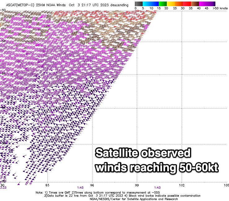
We saw a polar low 'bomb' early in the week, dropping over 24hPa in central pressure within 24 hours, and this has resulted in a fetch of severe-gale to storm-force W'ly winds being generated through our south-western swell window.
Satellite observations have picked up core wind speeds of 60kts and the low is now weakening, with severe-gales continuing through our swell window today before breaking down tomorrow.
A large, long-period SW groundswell is due from the low, arriving Friday and building rapidly into the afternoon. The Surf Coast is still on target to reach 6-8ft with 8-10ft sets to the east but with the pesky S/SW-S wind.
Easing, large surf from the 6ft range is expected on the Surf Coast Saturday, 8ft to the east but a stalling high to our west will maintain moderate to fresh S/SE winds. Lighter S'ly winds are due Sunday as the swell continues to ease, likely variable across Phillip Island offering workable options.

A fun, reinforcing pulse of SW groundswell is due on Monday, generated by a trailing front behind the polar low, generating gale to severe-gale W/NW winds across and east of the Heard Island region today, weakening tomorrow.
This should provide inconsistent 3-4ft sets on the Surf Coast magnets and 5-6ft sets to the east Monday morning but with pesky, lingering S/SW winds. Lighter S'ly winds and easing surf may be seen on Tuesday but it won't be until Wednesday that we see winds going N'ly again.
By then the swell will be smaller and back to 2ft+ on the Surf Coast and 3-4ft to the east.
Longer term the outlook is still so/so for the end of the week so make the most of tomorrow.


Comments
What the f..k is this? Since when does the SC go a week without pumping clean swell?
might have to move interstate if this continues
I hear Burleigh is welcoming Victorians to SE Queensland...
Edit: 'more' Victorians
burleigh heads... silicon,no carparks,right handerrrr good on its day i suppose never scored it, original home/bithplace to the bogan,warm. results were not as good as expetation.
Was having La Nina flashbacks yesterday, scary stuff
This month's wind is brought to you by the letter 'S'.
Rubbish Southerly winds .... go away !
Craigos will there be an update to the app to allow you to read and make comments ?
It's on the development roadmap SurfLad but isn't a priority at the moment.
Lovely cheers
Southerlies and a long period SW swell bring it on
Like an old girlfriend that turns up on the doorstep to cause trouble
Southerly on the surfcoast
What a joy !