Great period of surf with lots of swell and favourable winds
Victorian Surf Forecast by Craig Brokensha (issued Wednesday 12th July)
Best Days: Most days this period (least consistent tomorrow and Friday)
Features of the Forecast (tl;dr)
- Moderate sized, inconsistent W/SW groundswell peaking tomorrow (likely AM), easing Fri
- Strong N/NW winds tomorrow, strong N/NW-N winds Fri
- Late pulse of moderate sized mid-period W/SW swell Fri, peaking Sat with a further pulse into the PM
- Mod-fresh W/NW tending weaker W/SW winds Sat
- Moderate sized SW groundswell filling in Sunday, peaking in the PM, easing slowly Mon/Tue
- Fresh but easing NW winds Sun, mod-fresh N/NW Mon
- Strong NW tending SW winds Tue
- Moderate sized mid-period W/SW swell for Wed with N winds
Recap
Great conditions and surf all day yesterday across the Surf Coast with a reinforcing pulse of mid-period W/SW swell maintaining 4ft sets on the magnets, while locations to the east were average to poor and wind affected.
This morning the swell is easing with slower 3ft+ sets on the Surf Coast and more favourable conditions for the beaches, 4-6ft to the east with semi-protected spots fairing best.
This week and next week (Jul 13 - 21)

Inconsistent, that's the key word for tomorrow's new W/SW groundswell.
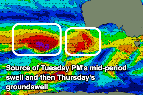
Wave heights will continue to tail off during today as winds hold from the N/NW-NW, while tomorrow we should see the arrival of a strong but inconsistent W/SW groundswell, generated through the southern Indian Ocean on the weekend.
A great fetch of gale to severe-gale W/NW winds pushed in behind a mid-latitude frontal system and active sea state, with the swell kicking to the XL range across the South West yesterday.
The west direction and significant distance between the source of the swell and our coast will see a loss in size and consistency but at the peak of the swell tomorrow we should see 3-4ft waves on the Surf Coast magnets with the rare 5ft'er likely (very infrequent), with 6ft surf to the east with the rare 8ft cleanup.
Winds will be strong but out of the N/NW all day, favouring selected locations, while Friday will see winds tending a touch more north, blowing strong N/NW-N all day as the swell eases.

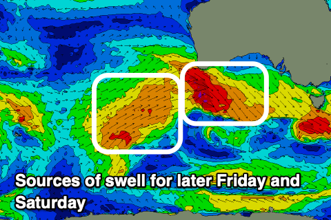
Persistent fronts generating fetches of strong to gale-force W/NW winds will produce some reinforcing mid-period W/SW swell for later Friday but more so Saturday, with a trailing fetch of strong W/SW winds on the back of all this activity due to produce a possible further pulse into the afternoon.
Size wise, the W/NW activity should produce good 3ft+ sets Saturday across the Surf Coast, 5-6ft to the east (possibly a little bigger into the afternoon).
Sunday looks to see even stronger surf building thanks to a good mid-latitude frontal system pushing in, under the country on Friday evening and Saturday, producing a fetch of W'ly gales on top an active sea state (below left).
This should see the surf building to the 5ft range on the Surf Coast magnets into the afternoon Sunday with 6-8ft sets to the east, easing slowly through Monday and Tuesday thanks to weaker, trailing frontal activity.

Looking at the local winds and moderate to fresh W/NW winds on Saturday morning will give into a shallow W/SW change through the afternoon and this won't do to much damage, with winds set to revert back to the NW on Sunday, fresh in the morning and lighter through the afternoon.
Great, moderate to fresh N/NW winds are due Monday as the swell eases, stronger Tuesday morning out of the NW ahead of an afternoon SW change. Wednesday at this stage may see morning N'ly winds and a moderate sized pulse of mid-period W/SW swell but we'll have a closer loom at this Friday.
Longer term the outlook remains very active, so all in all the good times keep on keeping on.v


Comments
That shallow SW change you had on Mon gave me hope. Was probably too much to ask for.
Very clean forey craigos!
fantastic run of waves craigos, many thanks for your blessings